 PIG-PIB Katalog metadanych eCUDO.pl
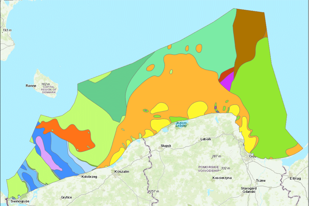
Pre-Quaternary geological map of the Baltic Sea
Mapa geologiczna Bałtyku bez osadów czwartorzędowych
The data present bedrocks of the bottom of Polish maritime areas
Dane prezentują podłoże osadów dna polskich obszarów morskich
Simple
-
Data (Publikacja)Date (Publication)
- 2007-06-01
-
IdentyfikatorIdentifier
- 74095eca-07b2-4e5f-acd4-a6ed29ea345d
-
StatusStatus
-
ZakończonyCompleted
-
GEMET - INSPIRE themes, version 1.0
GEMET - tematy INSPIRE, wersja 1.0
-
-
Geology
Geologia
-
Map chart
Mapa
- Inorganic chemical composition of sediment or rocks
- Marine geology
-
- Keywords
-
-
Geology
Geologia
-
-
SeaVoX Platform CategoriesKategorie platform SeaVoX
-
- research vessel
-
Continents, countries, sea regions of the world.
-
-
Baltic Sea
-
-
Use limitation
-
no conditions apply
-
Ograniczenia dostępuAccess constraints
-
Prawa autorskieCopyright
-
Typ reprezentacji przestrzennejSpatial representation type
-
WektorVector
-
OdległośćDistance
- 100 m
-
JęzykMetadata language
- English
-
Zbiór znakówCharacter set
-
Utf8UTF8
-
Kategoria tematycznaTopic category
-
-
ŚrodowiskoEnvironment
-
GeoinformacjaGeoscientific information
-
))
- Begin date
- 2007-01-01T23:00:00
- End date
- 2007-01-09T23:00:00
-
Unikalny identyfikator zasobuUnique resource identifier
-
43264326
- Codespace
-
SeaDataNet
-
Format dystrybucjiDistribution format
-
-
WMSWMS
(
1.3.0
)
-
WMSWMS
(
1.3.0
)
-
Zasób sieciowyOnLine resource
-
0
(
OGC:WMS-1.3.0-http-get-map
)
Budowa geologiczna powierzchni podczwartorzędowej
-
Zasób sieciowyOnLine resource
-
1
(
OGC:WMS-1.3.0-http-get-map
)
Izohipsy
-
Zasób sieciowyOnLine resource
-
2
(
OGC:WMS-1.3.0-http-get-map
)
Uskoki tektoniczne
-
Zasób sieciowyOnLine resource
-
3
(
OGC:WMS-1.3.0-http-get-map
)
Granice zasięgów
-
PoziomHierarchy level
-
Zbiór danychDataset
Wynik zgodności
Conformance result
-
Data (Publikacja)Date (Publication)
- 2010-12-08
-
Explanation
-
See the referenced specification
-
AprobataPass
- Yes
Wynik zgodności
Conformance result
-
Data (Publikacja)Date (Publication)
- 2008-12-04
-
Explanation
-
See the referenced specification
-
AprobataPass
- Yes
Wynik zgodności
Conformance result
-
Data (Publikacja)Date (Publication)
- 2014-07-23
-
Explanation
-
See the referenced specification
-
AprobataPass
- Yes
Wynik zgodności
Conformance result
-
Data (Publikacja)Date (Publication)
- 2016-06-20
-
Explanation
-
See the referenced specification
-
AprobataPass
- Yes
-
Statement
-
This data was obtained with an use of all known scientific standards.
-
Identyfikator plikuFile identifier
- 1c991206-9f60-4304-9d8e-454709563fe0 XML
-
JęzykMetadata language
- English
-
Zbiór znakówCharacter set
-
Utf8UTF8
-
Poziom hierarchiiHierarchy level
-
Zbiór danychDataset
-
Nazwa poziomu hierarchiiHierarchy level name
-
CDICDI
-
Oznaczenie daty metadanychDate stamp
- 2021-10-25T16:35:26
- Metadata standard name
-
ISO 19115/SeaDataNet profile
- Metadata standard version
-
1.0
Overviews
Spatial extent
Provided by
