 PIG-PIB Katalog metadanych eCUDO.pl
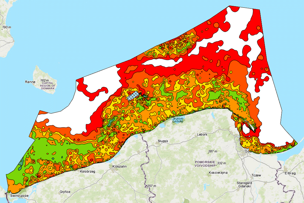
Atlas of lithological parameters of the Baltic Sea sediments - Sediments sorting
The map shows the degree of sediment sorting at the bottom of the Baltic Sea. The map is part of the "Atlas of lithological parameters of the Baltic Sea sediments".
The map shows the degree of sediment sorting at the bottom of the Baltic Sea. The map is part of the "Atlas of lithological parameters of the Baltic Sea sediments".
Mapa prezentuje stopień wysortowania osadów na dnie Bałtyku. Mapa jest częścią "Atlasu parametrów litologicznych osadów Bałtyku".
Simple
- Date (Publication)
- 2005-12-31
- Identifier
- urn:SDN:CDI:pgi.gov.pl:uuid:cf8499d8-75e6-4a7e-8184-6685627a08ea
- Status
- Completed
-
GEMET - INSPIRE themes, version 1.0
GEMET - INSPIRE themes, version 1.0
GEMET - tematy INSPIRE, wersja 1.0
-
-
Geology
Geology
Geologia
-
Map chart
Map chart
Mapa
- Marine geology
- Sediment
-
- SeaVoX Platform Categories
-
- research vessel
-
Continents, countries, sea regions of the world.
Continents, countries, sea regions of the world.
-
-
Baltic Sea
Baltic Sea
-
- BODC Parameter Discovery Vocabulary
-
- Lithology
- Use limitation
-
no conditions apply
no conditions apply
- Access constraints
- Copyright
- Spatial representation type
- Vector
- Distance
- 100 m
- Metadata language
- English
- Character set
- UTF8
- Topic category
-
- Environment
- Geoscientific information
))
- Begin date
- 2007-01-01T23:00:00
- End date
- 2007-01-09T23:00:00
- Unique resource identifier
- 4326
- Codespace
-
SeaDataNet
- Distribution format
-
-
WMS
(
1.3.0
)
-
WMS
(
1.3.0
)
- OnLine resource
-
Wysortowanie_osadów39511
(
OGC:WMS-1.3.0-http-get-map
)
Wysortowanie osadów
Wysortowanie osadów
- Hierarchy level
- Dataset
Conformance result
- Date (Publication)
- 2010-12-08
- Explanation
-
See the referenced specification
See the referenced specification
- Pass
- Yes
Conformance result
- Date (Publication)
- 2008-12-04
- Explanation
-
See the referenced specification
See the referenced specification
- Pass
- Yes
Conformance result
- Date (Publication)
- 2014-07-23
- Explanation
-
See the referenced specification
See the referenced specification
- Pass
- Yes
Conformance result
- Date (Publication)
- 2016-06-20
- Explanation
-
See the referenced specification
See the referenced specification
- Pass
- Yes
- Statement
-
This data was obtained with an use of all known scientific standards.
This data was obtained with an use of all known scientific standards.
- File identifier
- 3f3c23a3-c547-4d63-aa32-30767a5413ba XML
- Metadata language
- English
- Character set
- UTF8
- Hierarchy level
- Dataset
- Hierarchy level name
- CDI
- Date stamp
- 2022-05-04T15:26:44
- Metadata standard name
-
ISO 19115/SeaDataNet profile
- Metadata standard version
-
1.0
Overviews
Spatial extent
Provided by
