 PIG-PIB Katalog metadanych eCUDO.pl
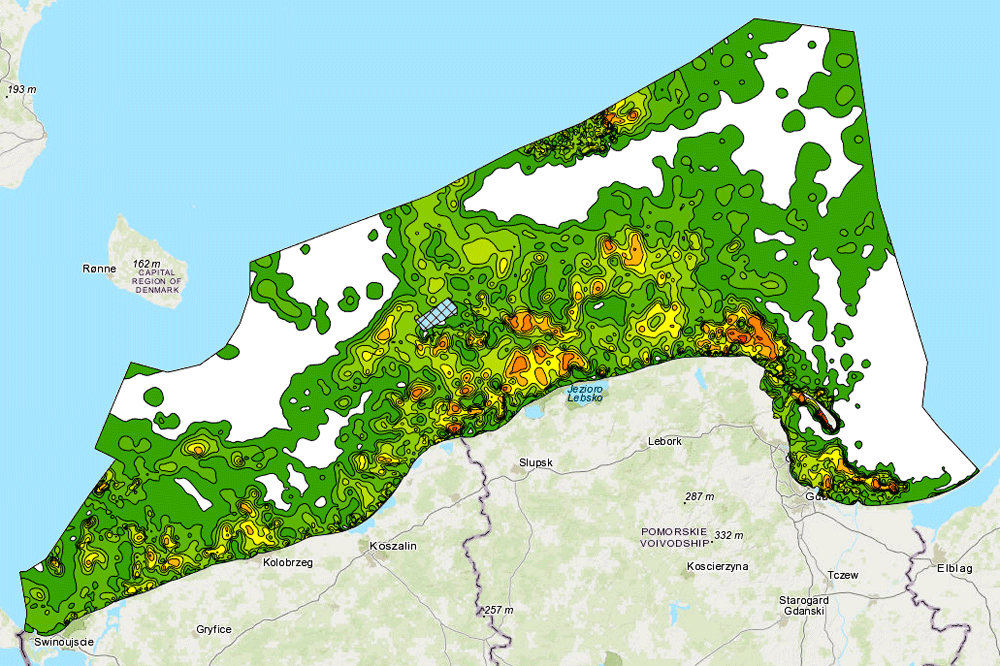
Atlas of lithological parameters of the Baltic Sea sediments - Percentage of fractions 0,25-0,5 mm.
Atlas parametrów litologicznych osadów Bałtyku - Frakcja 0,25-0,5 mm [%].
The map shows the percentage of fractions 0,25-0,5 mm at the bottom of the Baltic Sea. The map is part of the "Atlas of lithological parameters of the Baltic Sea sediments".
Mapa prezentuje frakcję 0,25-0,5 mm [%] na dnie Bałtyku. Mapa jest częścią "Atlasu parametrów litologicznych osadów Bałtyku".
Simple
-
Data (Publikacja)Date (Publication)
- 2005-12-31
-
IdentyfikatorIdentifier
- urn:SDN:CDI:pgi.gov.pl:uuid:cf8499d8-75e6-4a7e-8184-6685627a08ea
-
StatusStatus
-
ZakończonyCompleted
-
GEMET - INSPIRE themes, version 1.0
GEMET - tematy INSPIRE, wersja 1.0
-
-
Geology
Geologia
-
Map chart
Mapa
- Marine geology
- Sediment
-
-
SeaVoX Platform CategoriesKategorie platform SeaVoX
-
- research vessel
-
Continents, countries, sea regions of the world.
-
-
Baltic Sea
-
-
Use limitation
-
no conditions apply
-
Ograniczenia dostępuAccess constraints
-
Prawa autorskieCopyright
-
Typ reprezentacji przestrzennejSpatial representation type
-
WektorVector
-
OdległośćDistance
- 100 m
-
JęzykMetadata language
- English
-
Zbiór znakówCharacter set
-
Utf8UTF8
-
Kategoria tematycznaTopic category
-
-
ŚrodowiskoEnvironment
-
GeoinformacjaGeoscientific information
-
))
- Begin date
- 2007-01-01T23:00:00
- End date
- 2007-01-09T23:00:00
-
Unikalny identyfikator zasobuUnique resource identifier
-
43264326
- Codespace
-
SeaDataNet
-
Format dystrybucjiDistribution format
-
-
WMSWMS
(
1.3.0
)
-
WMSWMS
(
1.3.0
)
-
Zasób sieciowyOnLine resource
-
Frakcja_0_25-0_5_mm____2863
(
OGC:WMS-1.3.0-http-get-map
)
Frakcja 0
-
PoziomHierarchy level
-
Zbiór danychDataset
Wynik zgodności
Conformance result
-
Data (Publikacja)Date (Publication)
- 2010-12-08
-
Explanation
-
See the referenced specification
-
AprobataPass
- Yes
Wynik zgodności
Conformance result
-
Data (Publikacja)Date (Publication)
- 2008-12-04
-
Explanation
-
See the referenced specification
-
AprobataPass
- Yes
Wynik zgodności
Conformance result
-
Data (Publikacja)Date (Publication)
- 2014-07-23
-
Explanation
-
See the referenced specification
-
AprobataPass
- Yes
Wynik zgodności
Conformance result
-
Data (Publikacja)Date (Publication)
- 2016-06-20
-
Explanation
-
See the referenced specification
-
AprobataPass
- Yes
-
Statement
-
This data was obtained with an use of all known scientific standards.
-
Identyfikator plikuFile identifier
- b5769faf-32e7-4934-aad4-06f84de9b505 XML
-
JęzykMetadata language
- English
-
Zbiór znakówCharacter set
-
Utf8UTF8
-
Poziom hierarchiiHierarchy level
-
Zbiór danychDataset
-
Nazwa poziomu hierarchiiHierarchy level name
-
CDICDI
-
Oznaczenie daty metadanychDate stamp
- 2022-05-04T15:32:18
- Metadata standard name
-
ISO 19115/SeaDataNet profile
- Metadata standard version
-
1.0
Overviews
Spatial extent
Provided by
