 PIG-PIB Katalog metadanych eCUDO.pl
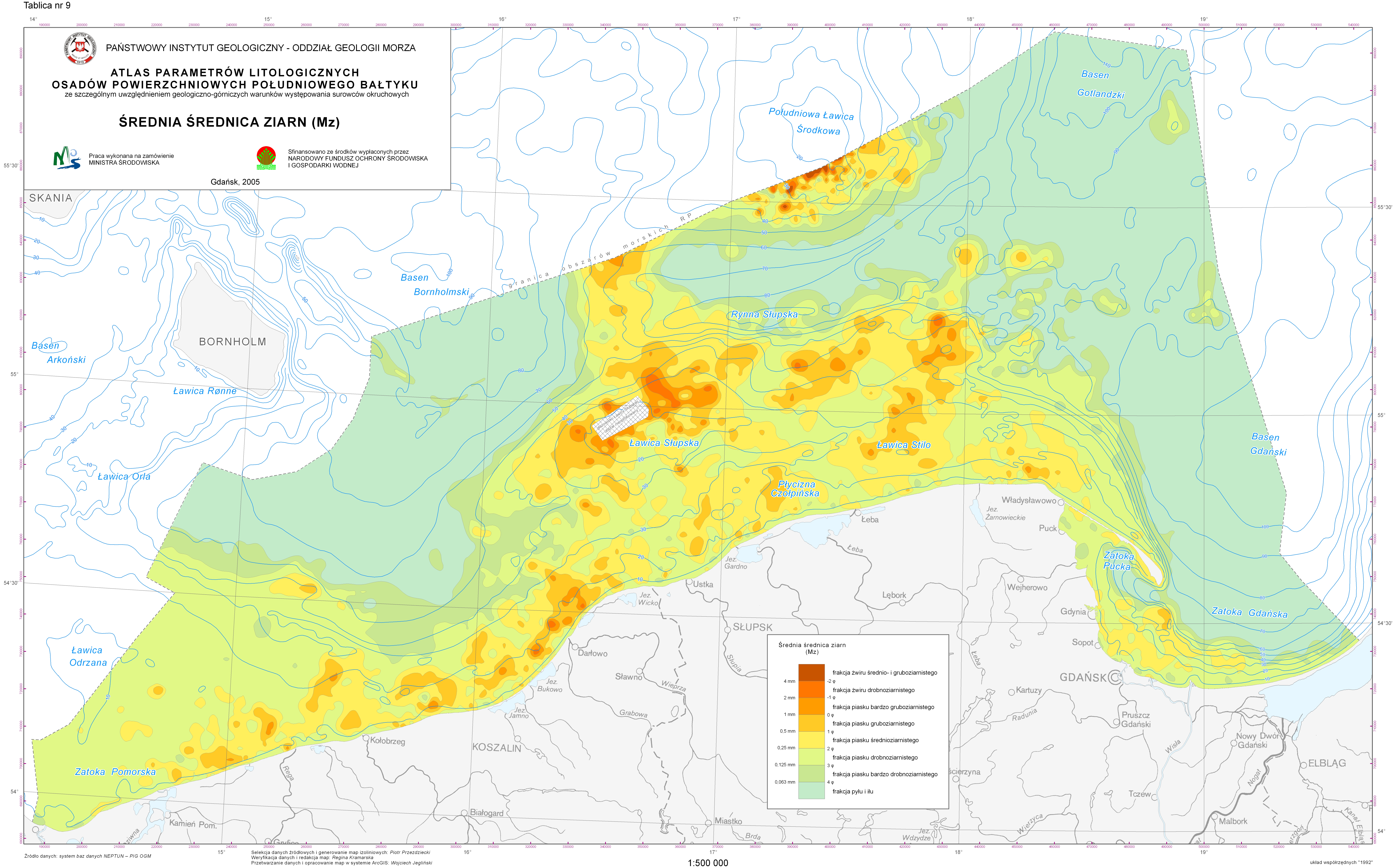
Baltic bottom lithology - average grain size (Mz)
Litologia dna Bałtyku - średnia średnica ziarn (Mz)
Baltic bottom lithology - average grain size (Mz)
The data comes from the "Atlas of lithological parameters of the Baltic Sea sediments" and presents average grain size (Mz) in the sediments of the bottom of Polish maritime areas
Dane pochodzą z "Atlasu parametrów litologicznych osadów Bałtyku" i prezentują średnią średnicę ziarn (Mz) w osadach dna polskich obszarów morskich
The data comes from the "Atlas of lithological parameters of the Baltic Sea sediments" and presents average grain size (Mz) in the sediments of the bottom of Polish maritime areas
Simple
-
Data (Publikacja)Date (Publication)
- 2022-09-01
-
IdentyfikatorIdentifier
- urn:SDN:CDI:pgi.gov.pl:15f9c095-d632-4e48-8bcf-1be3f5ef78f3
-
StatusStatus
-
ZakończonyCompleted
-
CI_PresentationFormCode
-
-
mapDigital
Mapa cyfrowa
Digital map
-
-
GEMET - INSPIRE themes, version 1.0
GEMET - INSPIRE themes, version 1.0
-
-
Geology
Geologia
Geology
-
-
SeaDataNet Device Categories
-
- research vessel
-
BODC Parameter Discovery VocabularySłownik parametrów badawczych BODCBODC Parameter Discovery Vocabulary
-
- Sediment grain size parameters
-
Continents, countries, sea regions of the world.
Continents, countries, sea regions of the world.
-
-
Baltic Sea
Bałtyk
Baltic Sea
-
-
Use limitationOgraniczenie korzystaniaUse limitation
-
no conditions apply
Nie obowiązują żadne warunki
No conditions apply
-
Other constraintsInne ograniczeniaOther constraints
-
Creative Commons Attribution 4.0 International LicenseCreative Commons Uznanie autorstwa 4.0 Międzynarodowa Licencja PublicznaCreative Commons Attribution 4.0 International License
-
Typ reprezentacji przestrzennejSpatial representation type
-
WektorVector
-
Typ reprezentacji przestrzennejSpatial representation type
-
mapDigitalmapDigital
-
OdległośćDistance
- 100 https://www.seadatanet.org/urnurl/SDN:P06::ULAA
-
JęzykMetadata language
- English
-
Zbiór znakówCharacter set
-
Utf8UTF8
-
Kategoria tematycznaTopic category
-
-
OceanyOceans
-
GeoinformacjaGeoscientific information
-
))
- Begin date
- 2002-01-01
- End date
- 2005-11-30
-
Unikalny identyfikator zasobuUnique resource identifier
-
43264326
- Codespace
-
SeaDataNet
-
Format dystrybucjiDistribution format
-
-
SHP
(
1
)
-
PNG
(
1.0
)
-
SHP
(
1
)
-
Zasób sieciowyOnLine resource
-
_rednia_średnica_ziarn_(Mz)15619Średnia średnica ziarn (Mz)Average grain size (Mz)
(
OGC:WMS-1.3.0-http-get-map
)
Average grain size
Średnia średnica ziarn
Average grain size
-
Zasób sieciowyOnLine resource
-
Average grain size (PNG file)Average grain size (plik PNG)Average grain size (PNG file)
(
WWW:DOWNLOAD-1.0-http--download
)
Average grain size (PNG file)
Average grain size (plik PNG)
Average grain size (PNG file)
-
Zasób sieciowyOnLine resource
-
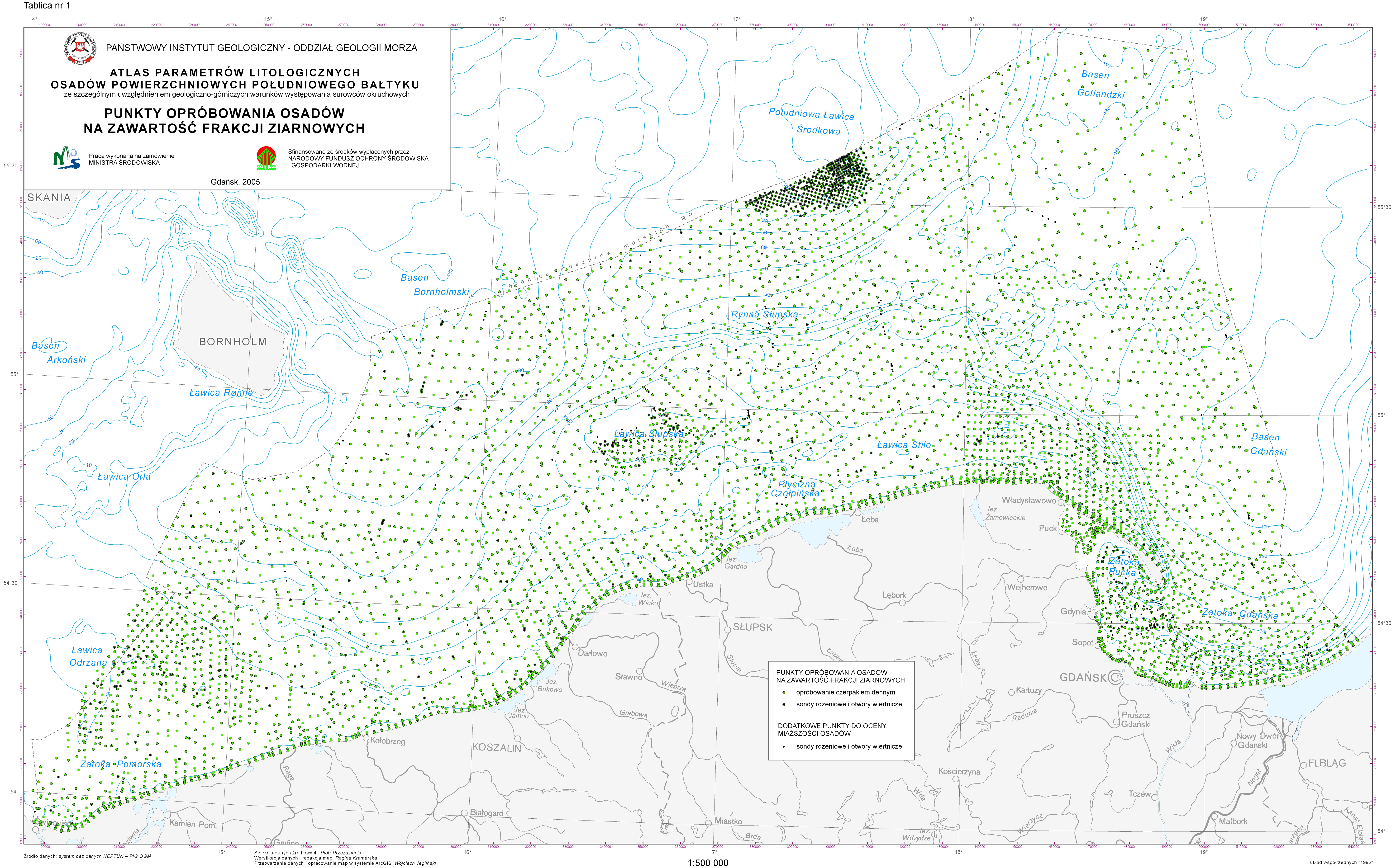
Sampling points for sediments granulation (PNG file)Punkty opróbowania osadów na zawartość frakcji ziarnowych (plik PNG)Sampling points for sediments granulation (PNG file)
(
WWW:DOWNLOAD-1.0-http--download
)
Sampling points for sediments granulation (PNG file)
Punkty opróbowania osadów na zawartość frakcji ziarnowych (plik PNG)
Sampling points for sediments granulation (PNG file)
-
Zasób sieciowyOnLine resource
-
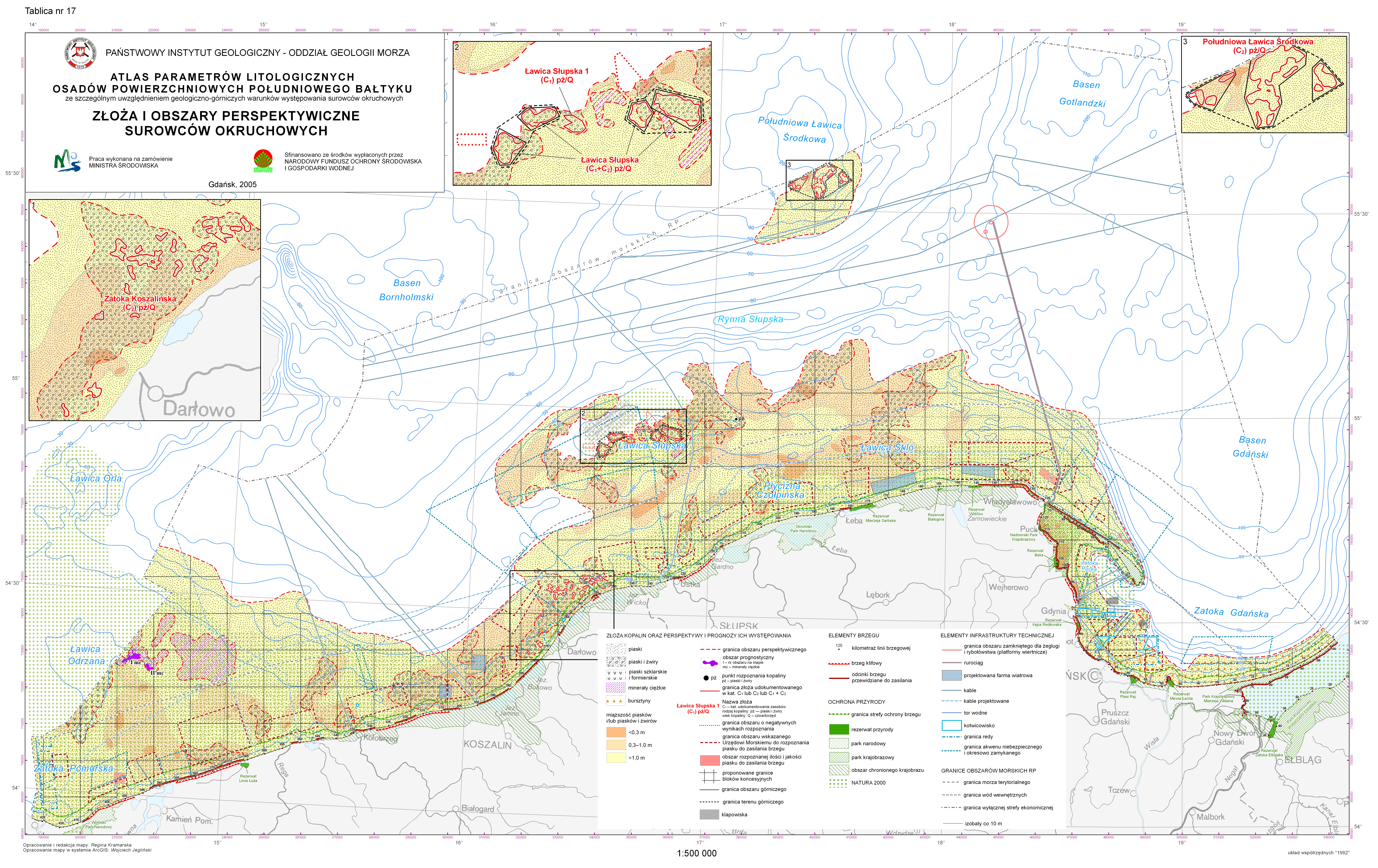
Deposits and prospective areas of clastic rock raw materials (PNG file)Punkty opróbowania osadów na zawartość frakcji ziarnowych (plik PNG)Deposits and prospective areas of clastic rock raw materials (PNG file)
(
WWW:DOWNLOAD-1.0-http--download
)
Deposits and prospective areas of clastic rock raw materials (PNG file)
Punkty opróbowania osadów na zawartość frakcji ziarnowych (plik PNG)
Deposits and prospective areas of clastic rock raw materials (PNG file)
-
Zasób sieciowyOnLine resource
-
Atlas text (PDF file)Tekst Atlasu (plik PDF)Atlas text (PDF file)
(
WWW:DOWNLOAD-1.0-http--download
)
Atlas text (PDF file)
Tekst Atlasu (plik PDF)
Atlas text (PDF file)
-
PoziomHierarchy level
-
Zbiór danychDataset
Wynik zgodności
Conformance result
-
Data (Publikacja)Date (Publication)
- 2010-12-08
-
Explanation
-
See the referenced specification
-
AprobataPass
- Yes
Wynik zgodności
Conformance result
-
Data (Publikacja)Date (Publication)
- 2008-12-04
-
Explanation
-
See the referenced specification
-
AprobataPass
- Yes
-
StatementOświadczenieStatement
-
This data was obtained with an use of all known scientific standards.
Dane te uzyskano z wykorzystaniem wszystkich znanych standardów naukowych.
This data was obtained with an use of all known scientific standards.
-
Identyfikator plikuFile identifier
- urn:SDN:CDI:pgi.gov.pl:15f9c095-d632-4e48-8bcf-1be3f5ef78f3 XML
-
JęzykMetadata language
- English
-
Zbiór znakówCharacter set
-
Utf8UTF8
-
Poziom hierarchiiHierarchy level
-
Zbiór danychDataset
-
Nazwa poziomu hierarchiiHierarchy level name
-
CDICDI
-
Oznaczenie daty metadanychDate stamp
- 2022-07-25T12:58:53
- Metadata standard name
-
ISO 19115/SeaDataNet profile
- Metadata standard version
-
1.0
Overviews
Spatial extent
Provided by
