 PIG-PIB Katalog metadanych eCUDO.pl
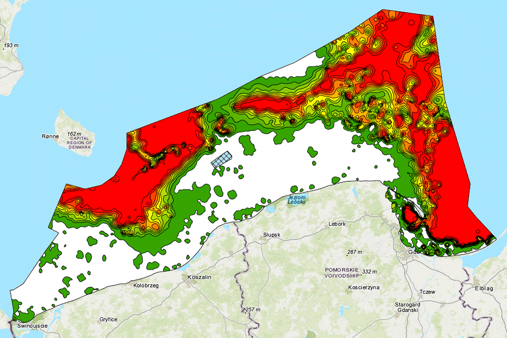
Litologia dna Bałtyku - frakcja <0,063 mm [%]
The data comes from the "Atlas of lithological parameters of the Baltic Sea sediments" and presents percentage of fractions <0,063 mm [%] in the bottom of Polish maritime areas
The data comes from the "Atlas of lithological parameters of the Baltic Sea sediments" and presents percentage of fractions <0,063 mm [%] in the bottom of Polish maritime areas
Dane pochodzą z "Atlasu parametrów litologicznych osadów Bałtyku" i prezentują zawartość frakcji <0,063 mm [%] w osadach dna polskich obszarów morskich
The data comes from the "Atlas of lithological parameters of the Baltic Sea sediments" and presents percentage of fractions <0,063 mm [%] in the bottom of Polish maritime areas
default
- Data (Publikacja)
- 2022-09-01
- Identyfikator
- urn:SDN:CDI:pgi.gov.pl:d37b6fd4-5eff-4102-87a8-1f5edd6d7fc8
- Status
- Zakończony
- CI_PresentationFormCode
-
-
mapDigital
mapDigital
Mapa cyfrowa
Digital map
-
-
GEMET - INSPIRE themes, version 1.0
GEMET - INSPIRE themes, version 1.0
GEMET - INSPIRE themes, version 1.0
-
-
Geology
Geology
Geologia
Geology
-
- SeaDataNet Device Categories
-
- research vessel
- Słownik parametrów badawczych BODC
-
- Sediment grain size parameters
-
Continents, countries, sea regions of the world.
Continents, countries, sea regions of the world.
Continents, countries, sea regions of the world.
-
-
Baltic Sea
Baltic Sea
Bałtyk
Baltic Sea
-
- Ograniczenie korzystania
-
no conditions apply
no conditions apply
Nie obowiązują żadne warunki
No conditions apply
- Inne ograniczenia
- Creative Commons Uznanie autorstwa 4.0 Międzynarodowa Licencja Publiczna
- Typ reprezentacji przestrzennej
- Wektor
- Typ reprezentacji przestrzennej
- mapDigital
- Odległość
- 100 https://www.seadatanet.org/urnurl/SDN:P06::ULAA
- Język
- English
- Zbiór znaków
- Utf8
- Kategoria tematyczna
-
- Oceany
- Geoinformacja
))
- Data początkowa
- 2002-01-01
- Data końcowa
- 2005-11-30
- Unikalny identyfikator zasobu
- 4326
- Kod przestrzeni
-
SeaDataNet
- Format dystrybucji
-
-
SHP
(
1
)
-
PNG
(
1.0
)
-
SHP
(
1
)
- Zasób sieciowy
-
Frakcja <0,063 mm [%]
(
OGC:WMS-1.3.0-http-get-map
)
Percentage of fractions <0,063 mm [%]
Percentage of fractions <0,063 mm [%]
Frakcja <0,063 mm [%]
Percentage of fractions <0,063 mm [%]
- Zasób sieciowy
-
Frakcja <0,063 mm [%] (plik PNG)
(
WWW:DOWNLOAD-1.0-http--download
)
Percentage of fractions <0,063 mm [%] (PNG file)
Percentage of fractions <0,063 mm [%] (PNG file)
Frakcja <0,063 mm [%] (plik PNG)
Percentage of fractions <0,063 mm [%] (PNG file)
- Zasób sieciowy
-
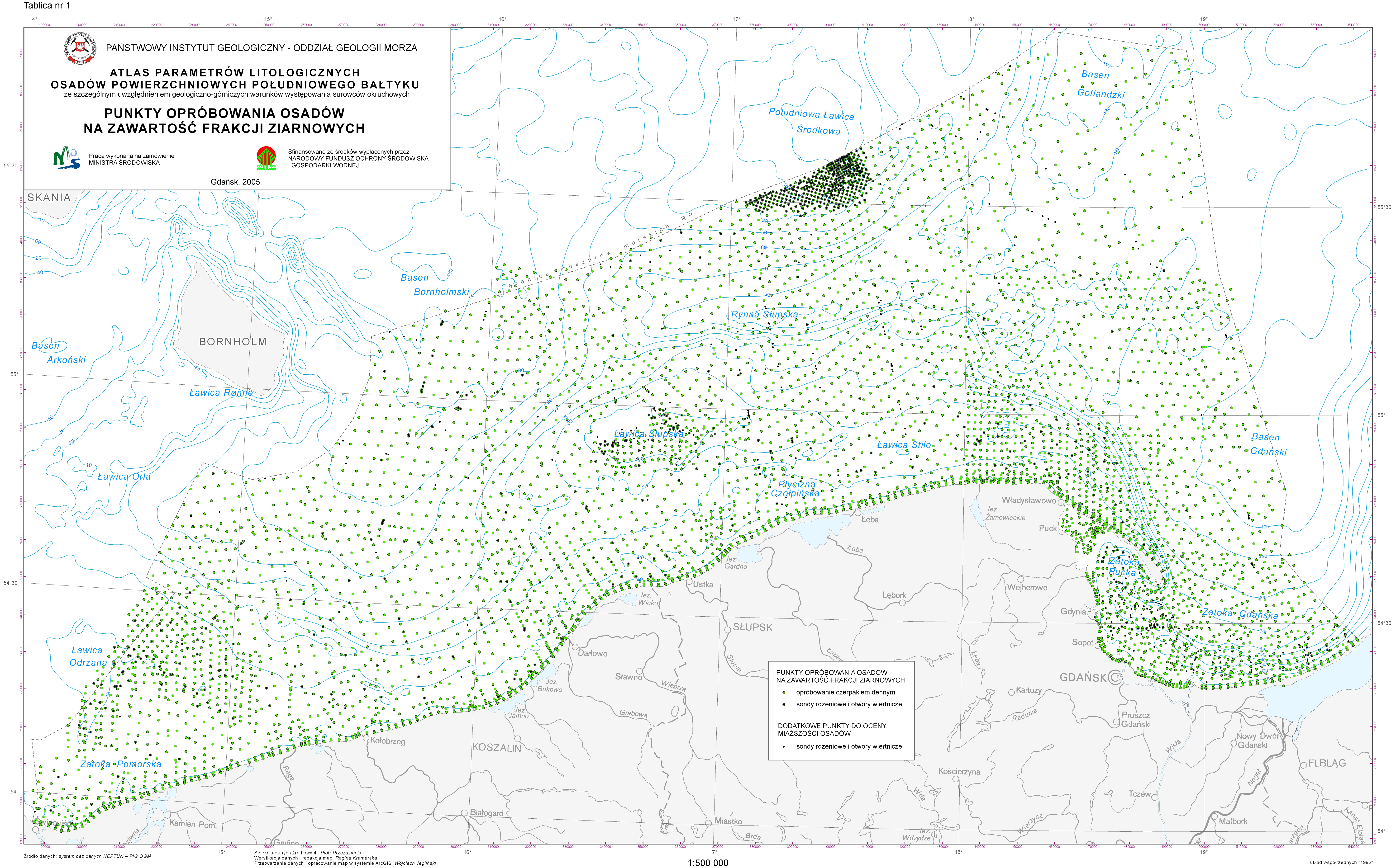
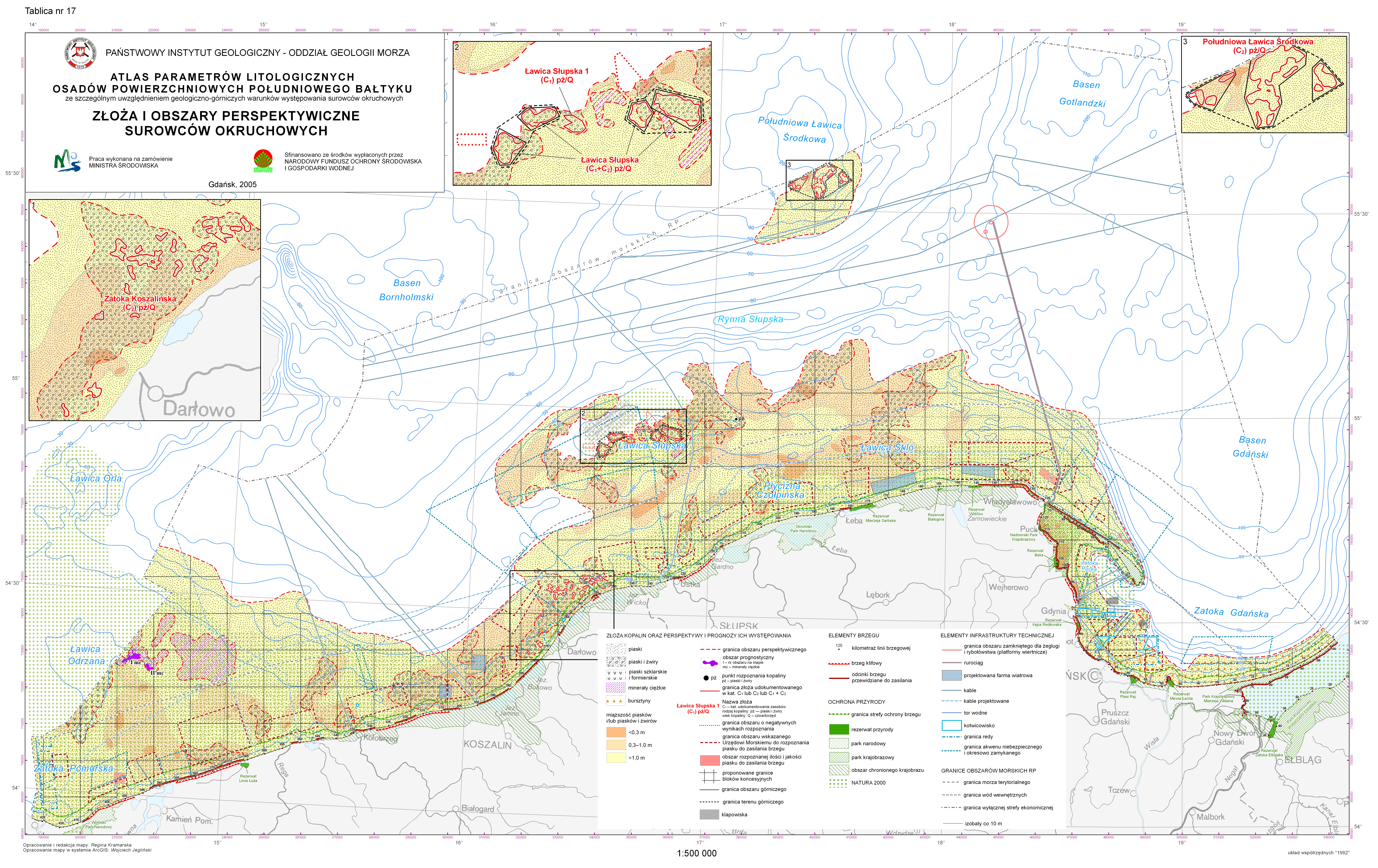
Punkty opróbowania osadów na zawartość frakcji ziarnowych (plik PNG)
(
WWW:DOWNLOAD-1.0-http--download
)
Sampling points for sediments granulation (PNG file)
Sampling points for sediments granulation (PNG file)
Punkty opróbowania osadów na zawartość frakcji ziarnowych (plik PNG)
Sampling points for sediments granulation (PNG file)
- Zasób sieciowy
-
Punkty opróbowania osadów na zawartość frakcji ziarnowych (plik PNG)
(
WWW:DOWNLOAD-1.0-http--download
)
Deposits and prospective areas of clastic rock raw materials (PNG file)
Deposits and prospective areas of clastic rock raw materials (PNG file)
Punkty opróbowania osadów na zawartość frakcji ziarnowych (plik PNG)
Deposits and prospective areas of clastic rock raw materials (PNG file)
- Zasób sieciowy
-
Tekst Atlasu (plik PDF)
(
WWW:DOWNLOAD-1.0-http--download
)
Atlas text (PDF file)
Atlas text (PDF file)
Tekst Atlasu (plik PDF)
Atlas text (PDF file)
- Poziom
- Zbiór danych
Wynik zgodności
- Data (Publikacja)
- 2010-12-08
- Wyjaśnienie
-
See the referenced specification
See the referenced specification
- Aprobata
- Yes
Wynik zgodności
- Data (Publikacja)
- 2008-12-04
- Wyjaśnienie
-
See the referenced specification
See the referenced specification
- Aprobata
- Yes
- Oświadczenie
-
This data was obtained with an use of all known scientific standards.
This data was obtained with an use of all known scientific standards.
Dane te uzyskano z wykorzystaniem wszystkich znanych standardów naukowych.
This data was obtained with an use of all known scientific standards.
- Identyfikator pliku
- urn:SDN:CDI:pgi.gov.pl:d37b6fd4-5eff-4102-87a8-1f5edd6d7fc8 XML
- Język
- English
- Zbiór znaków
- Utf8
- Poziom hierarchii
- Zbiór danych
- Nazwa poziomu hierarchii
- CDI
- Oznaczenie daty metadanych
- 2022-07-25T12:58:53
- Nazwa standardu metadanych
-
ISO 19115/SeaDataNet profile
- Wersja standardu metadanych
-
1.0

![Frakcja <0,063 mm [%] (plik PNG)](https://bazadata.pgi.gov.pl/data/baltyk/atlas-lito/atlas-lito-05-1.png)