PIG-PIB Katalog metadanych eCUDO.pl
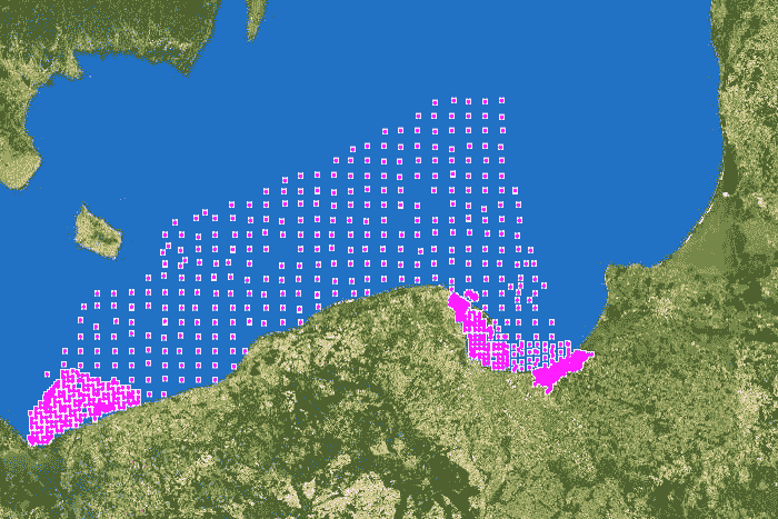
Punkty opróbowania na zawartość pierwiastków chemicznych
The data contain location of surface sediment samples for the content of chemical elements of the Polish maritime areas.
The data contain location of surface sediment samples for the content of chemical elements of the Polish maritime areas.
Dane zawierają lokalizację próbek osadów powierzchniowych na zawartość pierwiastków chemicznych polskich obszarów morskich.
The data contain location of surface sediment samples for the content of chemical elements of the Polish maritime areas.
default
- Data (Publikacja)
- 2022-06-14
- Identyfikator
- urn:SDN:CDI:pgi.gov.pl:uuid:43fd28a0-4323-439c-a2ee-6f4c8b6c851e
- Status
- Zakończony
- CI_PresentationFormCode
-
-
mapDigital
mapDigital
Mapa cyfrowa
Digital map
-
-
GEMET - INSPIRE themes, version 1.0
GEMET - INSPIRE themes, version 1.0
GEMET - INSPIRE themes, version 1.0
-
-
Geology
Geology
Geologia
Geology
-
- SeaDataNet Device Categories
-
- research vessel
- BODC Parameter Discovery Vocabulary
-
- Inorganic chemical composition of sediment or rocks
-
Continents, countries, sea regions of the world.
Continents, countries, sea regions of the world.
Continents, countries, sea regions of the world.
-
-
Baltic Sea
Baltic Sea
Bałtyk
Baltic Sea
-
- Ograniczenie korzystania
-
no conditions apply
no conditions apply
Nie obowiązują żadne warunki
No conditions apply
- Inne ograniczenia
- Creative Commons Uznanie autorstwa 4.0 Międzynarodowa Licencja Publiczna
- Typ reprezentacji przestrzennej
- Wektor
- Typ reprezentacji przestrzennej
- mapDigital
- Odległość
- 1 https://www.seadatanet.org/urnurl/SDN:P06::ULAA
- Język
- English
- Zbiór znaków
- Utf8
- Kategoria tematyczna
-
- Oceany
- Geoinformacja
))
- Data początkowa
- 1991-08-22
- Data końcowa
- 2011-12-31
- Unikalny identyfikator zasobu
- 4326
- Kod przestrzeni
-
SeaDataNet
- Format dystrybucji
-
-
A popular geospatial vector data format for geographic information system software developed and regulated by ESRI
(
1
)
-
GEOTIFF
(
1
)
-
A popular geospatial vector data format for geographic information system software developed and regulated by ESRI
(
1
)
- Zasób sieciowy
-
0
(
OGC:WMS-1.3.0-http-get-map
)
Sampling points - chemical analyzes
Sampling points - chemical analyzes
Punkty opróbowania - pierwiastki chemiczne
Sampling points - chemical analyzes
- Zasób sieciowy
-
Punkty opróbowania - pierwiastki chemiczne, plik SHP
(
WWW:DOWNLOAD-1.0-http--download
)
Sampling points - chemical analyzes, shapefile (SHP)
Sampling points - chemical analyzes, shapefile (SHP)
Punkty opróbowania - pierwiastki chemiczne, plik SHP
Sampling points - chemical analyzes, shapefile (SHP)
- Zasób sieciowy
-
Punkty opróbowania - pierwiastki chemiczne, GEO-TIFF
(
WWW:DOWNLOAD-1.0-http--download
)
Sampling points - chemical analyzes, GEO-TIFF
Sampling points - chemical analyzes, GEO-TIFF
Punkty opróbowania - pierwiastki chemiczne, GEO-TIFF
Sampling points - chemical analyzes, GEO-TIFF
- Poziom
- Zbiór danych
Wynik zgodności
- Data (Publikacja)
- 2010-12-08
- Wyjaśnienie
-
See the referenced specification
See the referenced specification
- Aprobata
- Yes
Wynik zgodności
- Data (Publikacja)
- 2008-12-04
- Wyjaśnienie
-
See the referenced specification
See the referenced specification
- Aprobata
- Yes
- Oświadczenie
-
This data was obtained with an use of all known scientific standards.
This data was obtained with an use of all known scientific standards.
Dane te uzyskano z wykorzystaniem wszystkich znanych standardów naukowych.
This data was obtained with an use of all known scientific standards.
- Identyfikator pliku
- urn:SDN:CDI:pgi.gov.pl:uuid:43fd28a0-4323-439c-a2ee-6f4c8b6c851e XML
- Język
- English
- Zbiór znaków
- Utf8
- Poziom hierarchii
- Zbiór danych
- Nazwa poziomu hierarchii
- CDI
- Oznaczenie daty metadanych
- 2022-07-25T12:58:53
- Nazwa standardu metadanych
-
ISO 19115/SeaDataNet profile
- Wersja standardu metadanych
-
1.0