 PIG-PIB Katalog metadanych eCUDO.pl
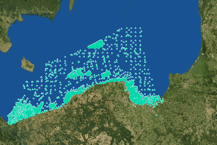
Sampling points with core samplers
The data contain location of surface sediment samples with core samplers of the Polish maritime areas.
The data contain location of surface sediment samples with core samplers of the Polish maritime areas.
Dane zawierają lokalizację próbek osadów powierzchniowych próbnikami rdzeniującymi.
The data contain location of surface sediment samples with core samplers of the Polish maritime areas.
Simple
- Date (Publication)
- 2022-06-14
- Identifier
- urn:SDN:CDI:pgi.gov.pl:uuid:8b594f94-ef9a-4c15-9c64-2e9c5c5cb734
- Status
- Completed
- CI_PresentationFormCode
-
-
mapDigital
mapDigital
Mapa cyfrowa
Digital map
-
-
GEMET - INSPIRE themes, version 1.0
GEMET - INSPIRE themes, version 1.0
GEMET - INSPIRE themes, version 1.0
-
-
Geology
Geology
Geologia
Geology
-
- SeaDataNet Device Categories
-
- research vessel
-
Continents, countries, sea regions of the world.
Continents, countries, sea regions of the world.
Continents, countries, sea regions of the world.
-
-
Baltic Sea
Baltic Sea
Bałtyk
Baltic Sea
-
- Use limitation
-
no conditions apply
no conditions apply
Nie obowiązują żadne warunki
No conditions apply
- Other constraints
- Creative Commons Attribution 4.0 International License
- Spatial representation type
- Vector
- Spatial representation type
- mapDigital
- Distance
- 1 https://www.seadatanet.org/urnurl/SDN:P06::ULAA
- Metadata language
- English
- Character set
- UTF8
- Topic category
-
- Oceans
- Geoscientific information
))
- Begin date
- 1961-12-31
- End date
- 2021-12-31
- Unique resource identifier
- 4326
- Codespace
-
SeaDataNet
- Distribution format
-
-
A popular geospatial vector data format for geographic information system software developed and regulated by ESRI
(
1
)
-
GEOTIFF
(
1
)
-
A popular geospatial vector data format for geographic information system software developed and regulated by ESRI
(
1
)
- OnLine resource
-
4
(
OGC:WMS-1.3.0-http-get-map
)
Sampling points - core samplers
Sampling points - core samplers
Punkty opróbowania - próbniki rdzeniujące
Sampling points - core samplers
- OnLine resource
-
Sampling points - core samplers, shapefile (SHP)
(
WWW:DOWNLOAD-1.0-http--download
)
Sampling points - core samplers, shapefile (SHP)
Sampling points - core samplers, shapefile (SHP)
Punkty opróbowania - próbniki rdzeniujące, plik SHP
Sampling points - core samplers, shapefile (SHP)
- OnLine resource
-
Sampling points - core samplers, GEO-TIFF
(
WWW:DOWNLOAD-1.0-http--download
)
Sampling points - core samplers, GEO-TIFF
Sampling points - core samplers, GEO-TIFF
Punkty opróbowania - próbniki rdzeniujące, GEO-TIFF
Sampling points - core samplers, GEO-TIFF
- Hierarchy level
- Dataset
Conformance result
- Date (Publication)
- 2010-12-08
- Explanation
-
See the referenced specification
See the referenced specification
- Pass
- Yes
Conformance result
- Date (Publication)
- 2008-12-04
- Explanation
-
See the referenced specification
See the referenced specification
- Pass
- Yes
- Statement
-
This data was obtained with an use of all known scientific standards.
This data was obtained with an use of all known scientific standards.
Dane te uzyskano z wykorzystaniem wszystkich znanych standardów naukowych.
This data was obtained with an use of all known scientific standards.
- File identifier
- urn:SDN:CDI:pgi.gov.pl:uuid:8b594f94-ef9a-4c15-9c64-2e9c5c5cb734 XML
- Metadata language
- English
- Character set
- UTF8
- Hierarchy level
- Dataset
- Hierarchy level name
- CDI
- Date stamp
- 2022-07-25T12:58:53
- Metadata standard name
-
ISO 19115/SeaDataNet profile
- Metadata standard version
-
1.0
Overviews
Spatial extent
Provided by
