 PIG-PIB Katalog metadanych eCUDO.pl
4D cartography in the coastal zone of the southern Baltic Sea
4D cartography in the coastal zone of the southern Baltic Sea. The main goals of the project: Reconstruction - recognition of the processes and trends taking place on the coast in the past; The present - possibly faithful depiction of the coastal zone in its present shape; Forecast - the formulation of possible directions for the development of the border zone.
4D cartography in the coastal zone of the southern Baltic Sea. The main goals of the project: Reconstruction - recognition of the processes and trends taking place on the coast in the past; The present - possibly faithful depiction of the coastal zone in its present shape; Forecast - the formulation of possible directions for the development of the border zone.
Kartografia 4D w strefie brzegowej południowego Bałtyku. Główne cele projektu: Rekonstrukcja – czyli rozpoznanie procesów i trendy zachodzące na wybrzeżu w przeszłości; Teraźniejszość – czyli możliwie wierne zobrazowanie strefy brzegowej w jej obecnym kształcie; Prognoza – czyli sformułowanie możliwych kierunków rozwoju strefy brzegowej.
4D cartography in the coastal zone of the southern Baltic Sea. The main goals of the project: Reconstruction - recognition of the processes and trends taking place on the coast in the past; The present - possibly faithful depiction of the coastal zone in its present shape; Forecast - the formulation of possible directions for the development of the border zone.
Simple
- Date (Publication)
- 2022-10-14
- Identifier
- urn:SDN:CDI:pgi.gov.pl:uuid:964c8d91-d436-4b64-a1c0-b6087384d8f5
- Status
- on going
- CI_PresentationFormCode
-
-
mapDigital
mapDigital
Mapa cyfrowa
Digital map
-
- Oregon Coastal Atlas Coastal Erosion Thesaurus discovery terms
-
-
Natural hazards
Natural hazards
Zagrożenia naturalne
Natural hazards
-
- Oregon Coastal Atlas Coastal Erosion Thesaurus markup terms
-
-
Landslide
Landslide
Osuwisko
Landslide
-
-
GEMET - INSPIRE themes, version 1.0
GEMET - INSPIRE themes, version 1.0
GEMET - INSPIRE themes, version 1.0
-
-
Geology
Geology
Geologia
Geology
-
-
Continents, countries, sea regions of the world.
Continents, countries, sea regions of the world.
Continents, countries, sea regions of the world.
-
-
Baltic Sea
Baltic Sea
Bałtyk
Baltic Sea
-
- Use limitation
-
no conditions apply
no conditions apply
Nie obowiązują żadne warunki
No conditions apply
- Other constraints
- Creative Commons Attribution 4.0 International License
- Spatial representation type
- mapDigital
- Distance
- 3 https://www.seadatanet.org/urnurl/SDN:P06::ULAA
- Metadata language
- English
- Character set
- UTF8
- Topic category
-
- Oceans
- Geoscientific information
))
- Begin date
- 2015-01-01
- End date
- 2019-12-31
- Unique resource identifier
- 4326
- Codespace
-
SeaDataNet
- Distribution format
-
-
INAPP
(
1
)
-
INAPP
(
1
)
- OnLine resource
-
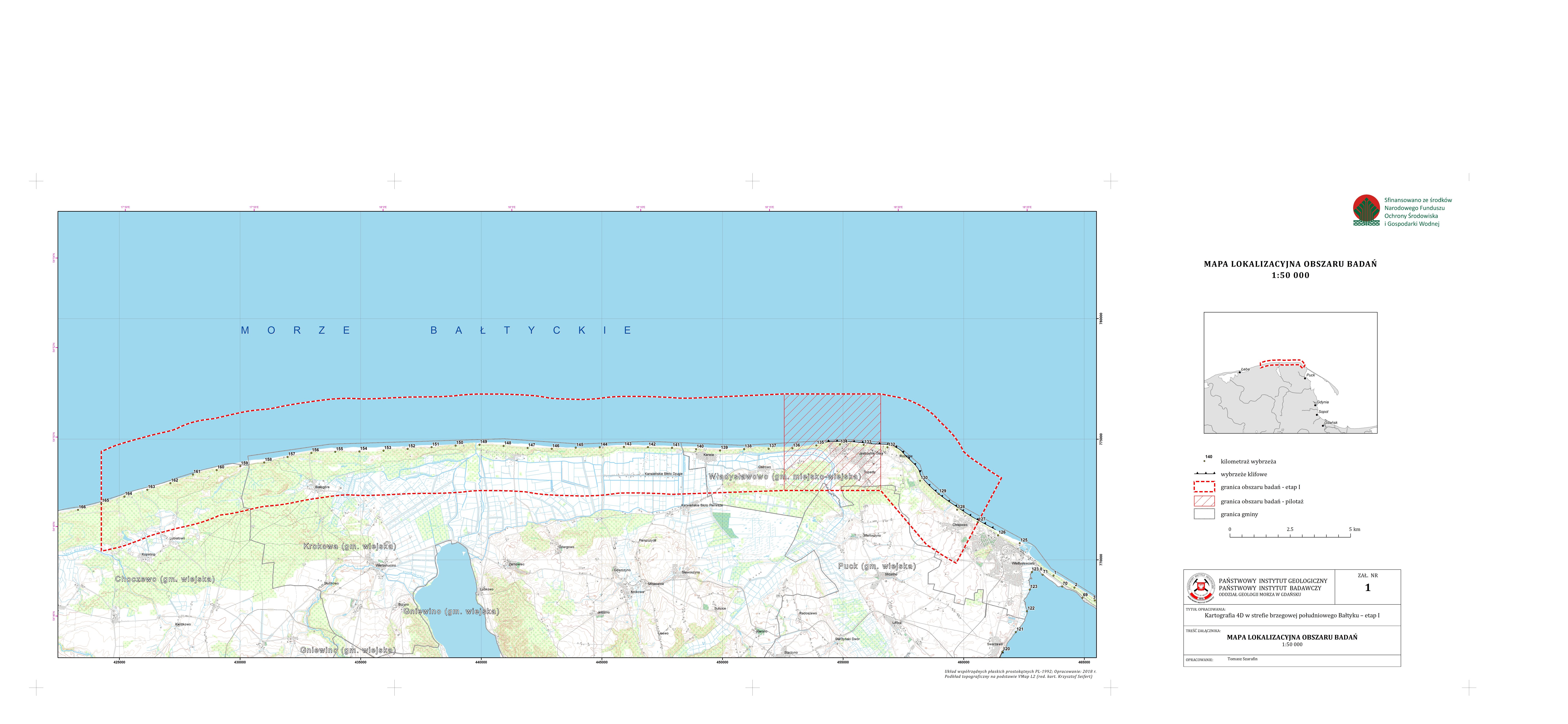
C4D - Location map of the research area
(
WWW:DOWNLOAD-1.0-http--download
)
C4D - Location map of the research area
C4D - Location map of the research area
K4D - Mapa lokalizacyjna obszaru badań
C4D - Location map of the research area
- OnLine resource
-
C4D - Documentation map
(
WWW:DOWNLOAD-1.0-http--download
)
C4D - Documentation map
C4D - Documentation map
K4D - Mapa dokumentacyjna
C4D - Documentation map
- OnLine resource
-
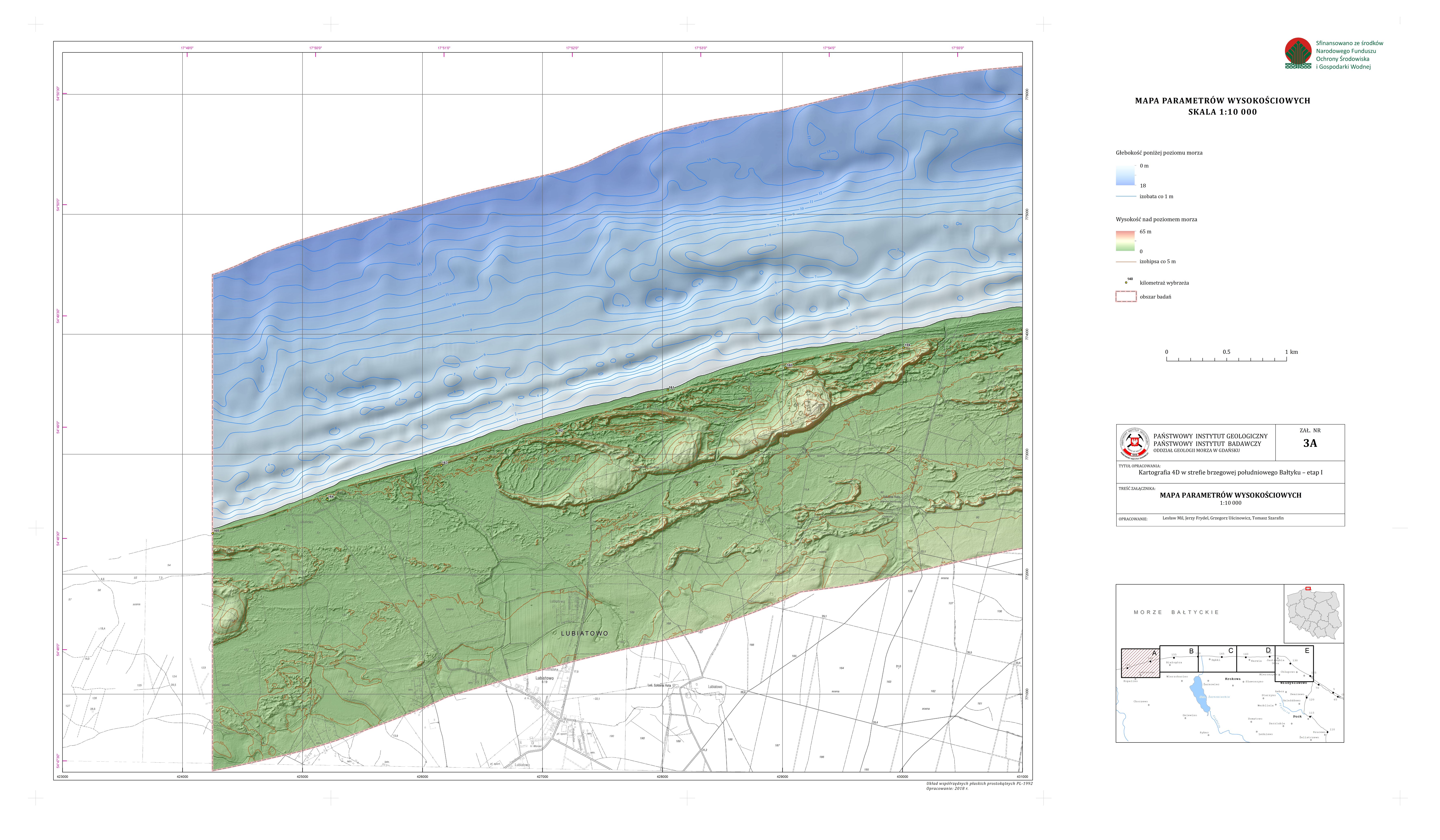
C4D - Map of elevation parameters (A)
(
WWW:DOWNLOAD-1.0-http--download
)
C4D - Map of elevation parameters (A)
C4D - Map of elevation parameters (A)
K4D - Mapa parametrów wysokościowych (A)
C4D - Map of elevation parameters (A)
- OnLine resource
-
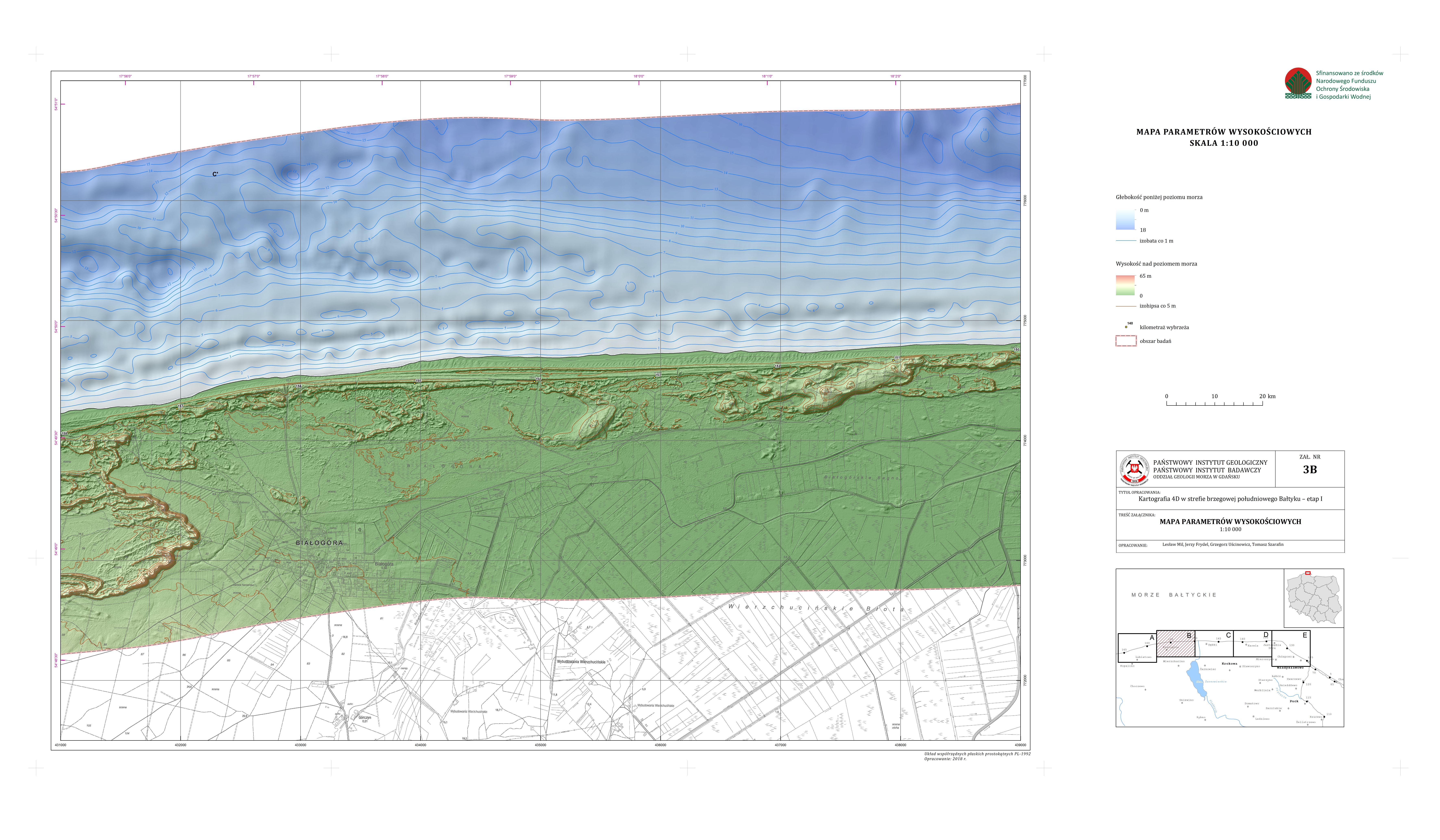
C4D - Map of elevation parameters (B)
(
WWW:DOWNLOAD-1.0-http--download
)
C4D - Map of elevation parameters (B)
C4D - Map of elevation parameters (B)
K4D - Mapa parametrów wysokościowych (B)
C4D - Map of elevation parameters (B)
- OnLine resource
-
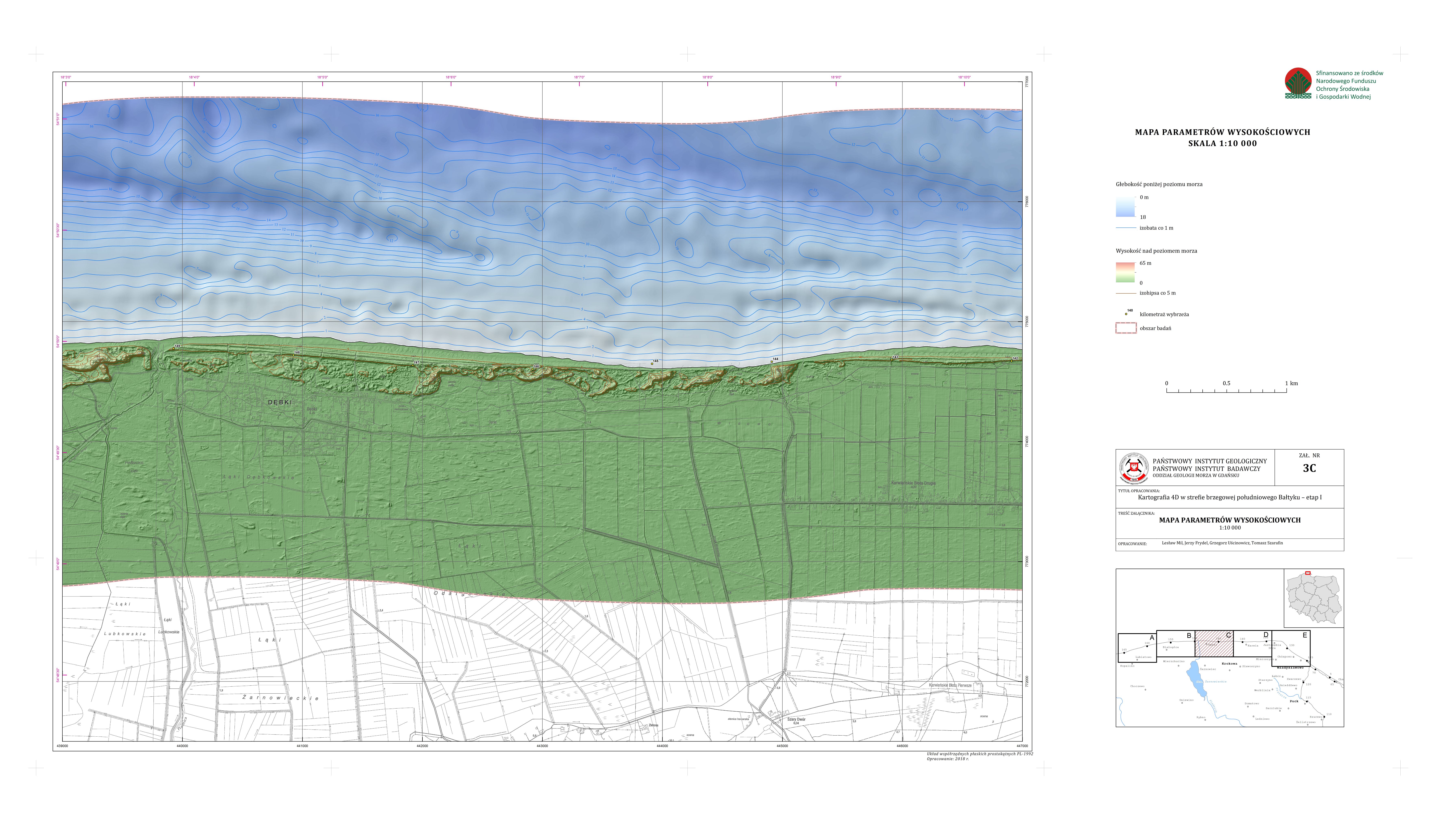
C4D - Map of elevation parameters (C)
(
WWW:DOWNLOAD-1.0-http--download
)
C4D - Map of elevation parameters (C)
C4D - Map of elevation parameters (C)
K4D - Mapa parametrów wysokościowych (C)
C4D - Map of elevation parameters (C)
- OnLine resource
-
C4D - Map of elevation parameters (D)
(
WWW:DOWNLOAD-1.0-http--download
)
C4D - Map of elevation parameters (D)
C4D - Map of elevation parameters (D)
K4D - Mapa parametrów wysokościowych (D)
C4D - Map of elevation parameters (D)
- OnLine resource
-
C4D - Map of elevation parameters (E)
(
WWW:DOWNLOAD-1.0-http--download
)
C4D - Map of elevation parameters (E)
C4D - Map of elevation parameters (E)
K4D - Mapa parametrów wysokościowych (E)
C4D - Map of elevation parameters (E)
- OnLine resource
-
C4D - Morphodynamic map of cliffs (A)
(
WWW:DOWNLOAD-1.0-http--download
)
C4D - Morphodynamic map of cliffs (A)
C4D - Morphodynamic map of cliffs (A)
K4D - Mapa morfodynamiczna wybrzeży klifowych (A)
C4D - Morphodynamic map of cliffs (A)
- OnLine resource
-
C4D - Morphodynamic map of cliffs (B)
(
WWW:DOWNLOAD-1.0-http--download
)
C4D - Morphodynamic map of cliffs (B)
C4D - Morphodynamic map of cliffs (B)
K4D - Mapa morfodynamiczna wybrzeży klifowych (B)
C4D - Morphodynamic map of cliffs (B)
- OnLine resource
-
C4D - Morphodynamic map of cliffs - slope profiles
(
WWW:DOWNLOAD-1.0-http--download
)
C4D - Morphodynamic map of cliffs - slope profiles
C4D - Morphodynamic map of cliffs - slope profiles
K4D - Mapa morfodynamiczna wybrzeży klifowych - profile zboczy
C4D - Morphodynamic map of cliffs - slope profiles
- OnLine resource
-
C4D - Morphodynamic map of dune-spit coasts
(
WWW:DOWNLOAD-1.0-http--download
)
C4D - Morphodynamic map of dune-spit coasts
C4D - Morphodynamic map of dune-spit coasts
K4D - Mapa morfodynamiczna wybrzeży wydmowo-mierzejowych
C4D - Morphodynamic map of dune-spit coasts
- OnLine resource
-
C4D - Lithogenetic map (A)
(
WWW:DOWNLOAD-1.0-http--download
)
C4D - Lithogenetic map (A)
C4D - Lithogenetic map (A)
K4D - Mapa litogenetyczna (A)
C4D - Lithogenetic map (A)
- OnLine resource
-
C4D - Lithogenetic map (B)
(
WWW:DOWNLOAD-1.0-http--download
)
C4D - Lithogenetic map (B)
C4D - Lithogenetic map (B)
K4D - Mapa litogenetyczna (B)
C4D - Lithogenetic map (B)
- OnLine resource
-
C4D - Lithogenetic map (C)
(
WWW:DOWNLOAD-1.0-http--download
)
C4D - Lithogenetic map (C)
C4D - Lithogenetic map (C)
K4D - Mapa litogenetyczna (C)
C4D - Lithogenetic map (C)
- OnLine resource
-
C4D - Lithogenetic map (D)
(
WWW:DOWNLOAD-1.0-http--download
)
C4D - Lithogenetic map (D)
C4D - Lithogenetic map (D)
K4D - Mapa litogenetyczna (D)
C4D - Lithogenetic map (D)
- OnLine resource
-
C4D - Lithogenetic map (E)
(
WWW:DOWNLOAD-1.0-http--download
)
C4D - Lithogenetic map (E)
C4D - Lithogenetic map (E)
K4D - Mapa litogenetyczna (E)
C4D - Lithogenetic map (E)
- OnLine resource
-
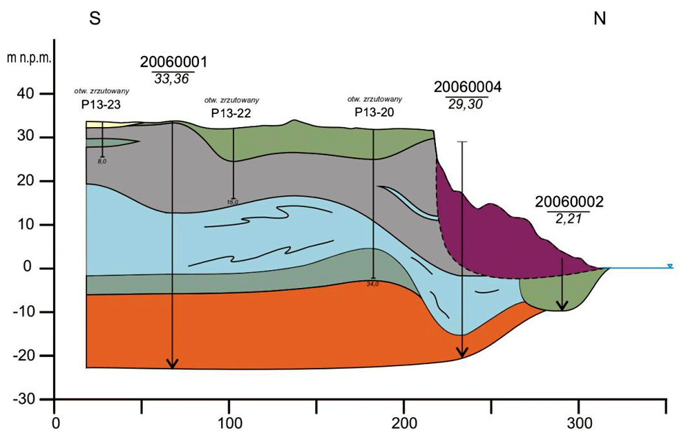
C4D - Geological cross-sections
(
WWW:DOWNLOAD-1.0-http--download
)
C4D - Geological cross-sections
C4D - Geological cross-sections
K4D - Przekroje geologiczne
C4D - Geological cross-sections
- OnLine resource
-
C4D - Selected seismoacoustic profiles
(
WWW:DOWNLOAD-1.0-http--download
)
C4D - Selected seismoacoustic profiles
C4D - Selected seismoacoustic profiles
K4D - Wybrane profile sejsmoakustyczne
C4D - Selected seismoacoustic profiles
- OnLine resource
-
C4D - Thickness map of the marine sandy cover
(
WWW:DOWNLOAD-1.0-http--download
)
C4D - Thickness map of the marine sandy cover
C4D - Thickness map of the marine sandy cover
K4D - Mapa miąższości morskiej pokrywy piaszczystej
C4D - Thickness map of the marine sandy cover
- OnLine resource
-
C4D - Map of lithological parameters of seabed sediments
(
WWW:DOWNLOAD-1.0-http--download
)
C4D - Map of lithological parameters of seabed sediments
C4D - Map of lithological parameters of seabed sediments
K4D - Mapa parametrów litologicznych osadów dna morskiego
C4D - Map of lithological parameters of seabed sediments
- OnLine resource
-
C4D - Fraction distribution map
(
WWW:DOWNLOAD-1.0-http--download
)
C4D - Fraction distribution map
C4D - Fraction distribution map
K4D - Mapa rozkładu frakcji
C4D - Fraction distribution map
- OnLine resource
-
C4D - Hydrogeological map
(
WWW:DOWNLOAD-1.0-http--download
)
C4D - Hydrogeological map
C4D - Hydrogeological map
K4D - Mapa hydrogeologiczna
C4D - Hydrogeological map
- OnLine resource
-
C4D - Hydrogeological cross-sections
(
WWW:DOWNLOAD-1.0-http--download
)
C4D - Hydrogeological cross-sections
C4D - Hydrogeological cross-sections
K4D - Przekroje hydrogeologiczne
C4D - Hydrogeological cross-sections
- OnLine resource
-
C4D - Model of hydrodynamic conditions
(
WWW:DOWNLOAD-1.0-http--download
)
C4D - Model of hydrodynamic conditions
C4D - Model of hydrodynamic conditions
K4D - Model warunków hydrodynamicznych
C4D - Model of hydrodynamic conditions
- OnLine resource
-
C4D - Synthetic geological cross-sections of cliffs
(
WWW:DOWNLOAD-1.0-http--download
)
C4D - Synthetic geological cross-sections of cliffs
C4D - Synthetic geological cross-sections of cliffs
K4D - Syntetyczne przekroje geologiczne klifów
C4D - Synthetic geological cross-sections of cliffs
- OnLine resource
-
C4D - Slope stability tests
(
WWW:DOWNLOAD-1.0-http--download
)
C4D - Slope stability tests
C4D - Slope stability tests
K4D - Testy stateczności skarpy
C4D - Slope stability tests
- OnLine resource
-
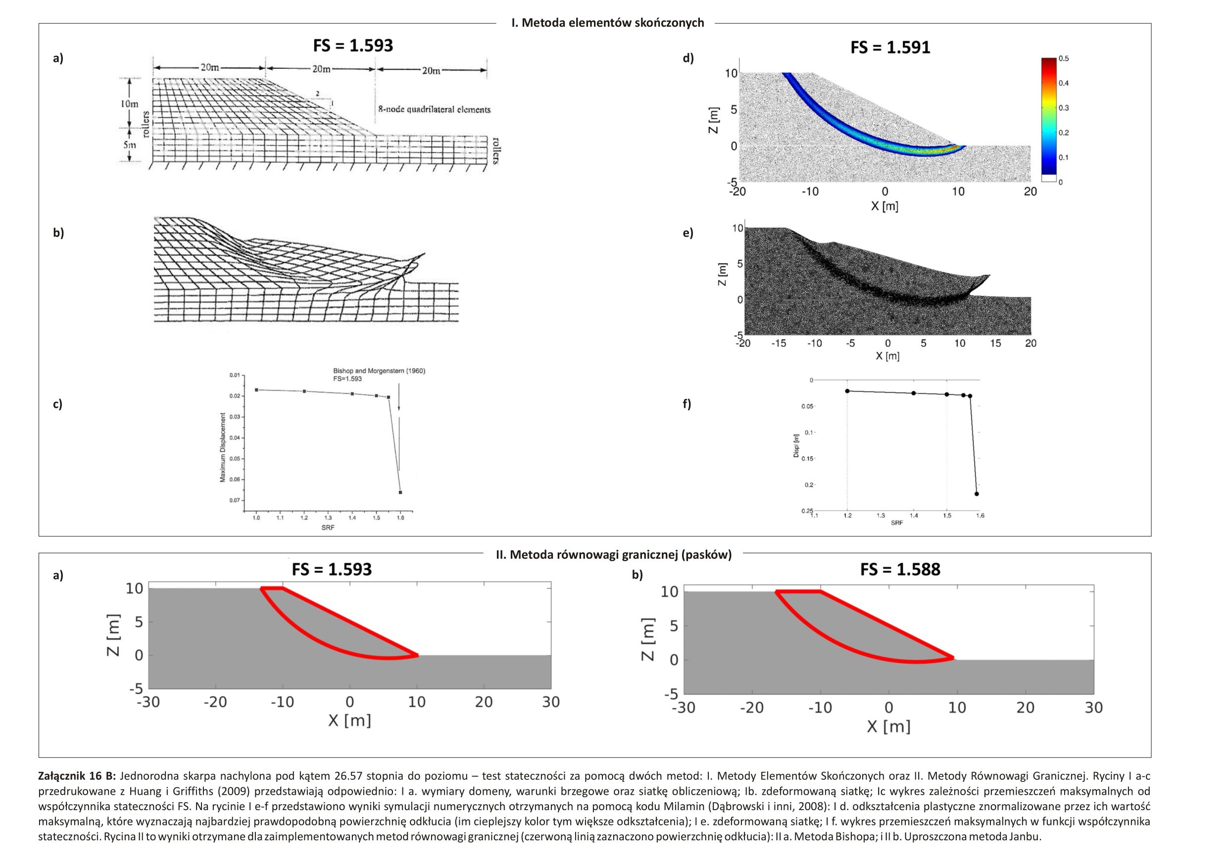
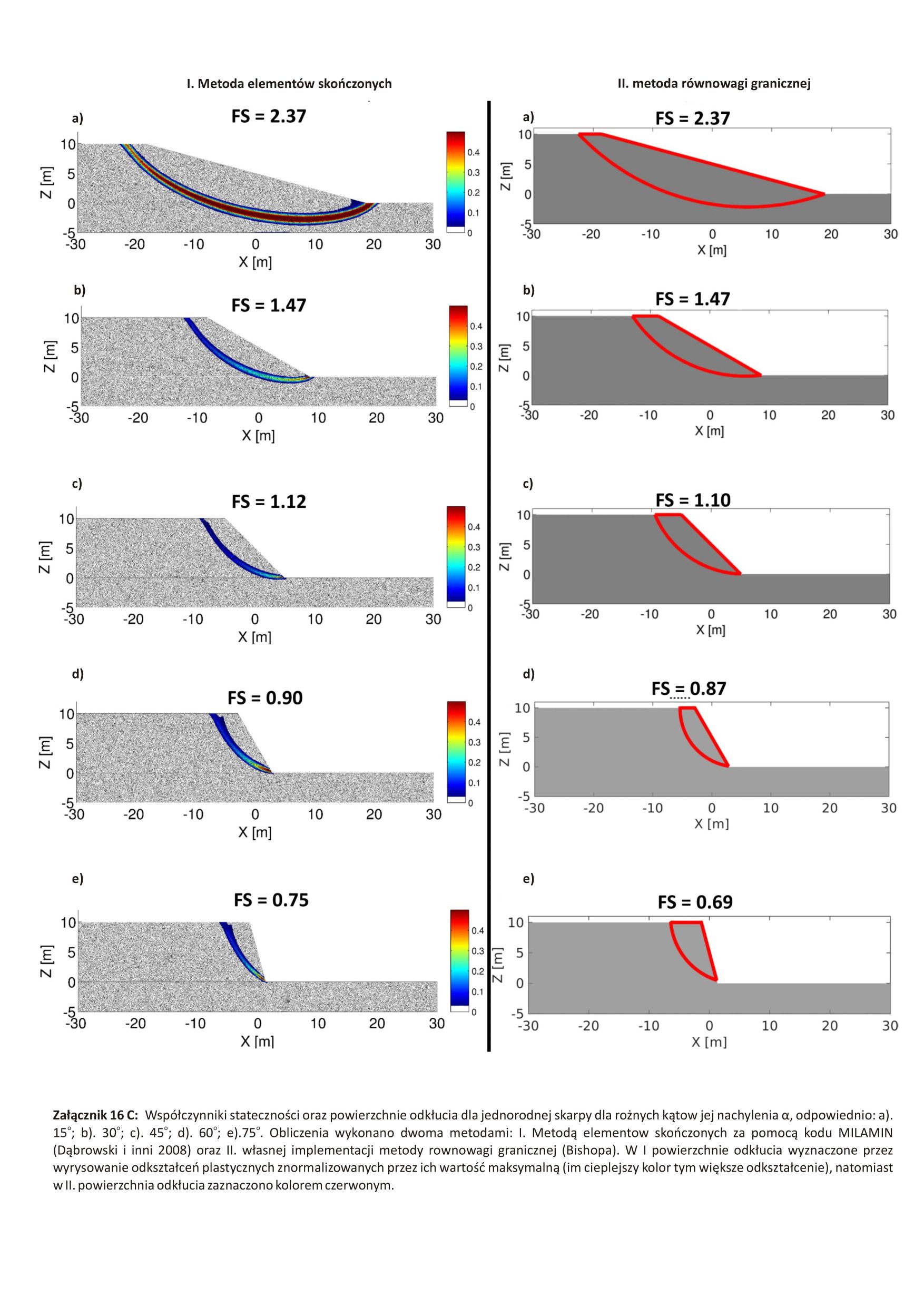
C4D - The coefficient of stability and the surfaces of the slope rupture
(
WWW:DOWNLOAD-1.0-http--download
)
C4D - The coefficient of stability and the surfaces of the slope rupture
C4D - The coefficient of stability and the surfaces of the slope rupture
K4D - Współczynniki stateczności oraz powierzchnie odkłucia skarpy
C4D - The coefficient of stability and the surfaces of the slope rupture
- OnLine resource
-
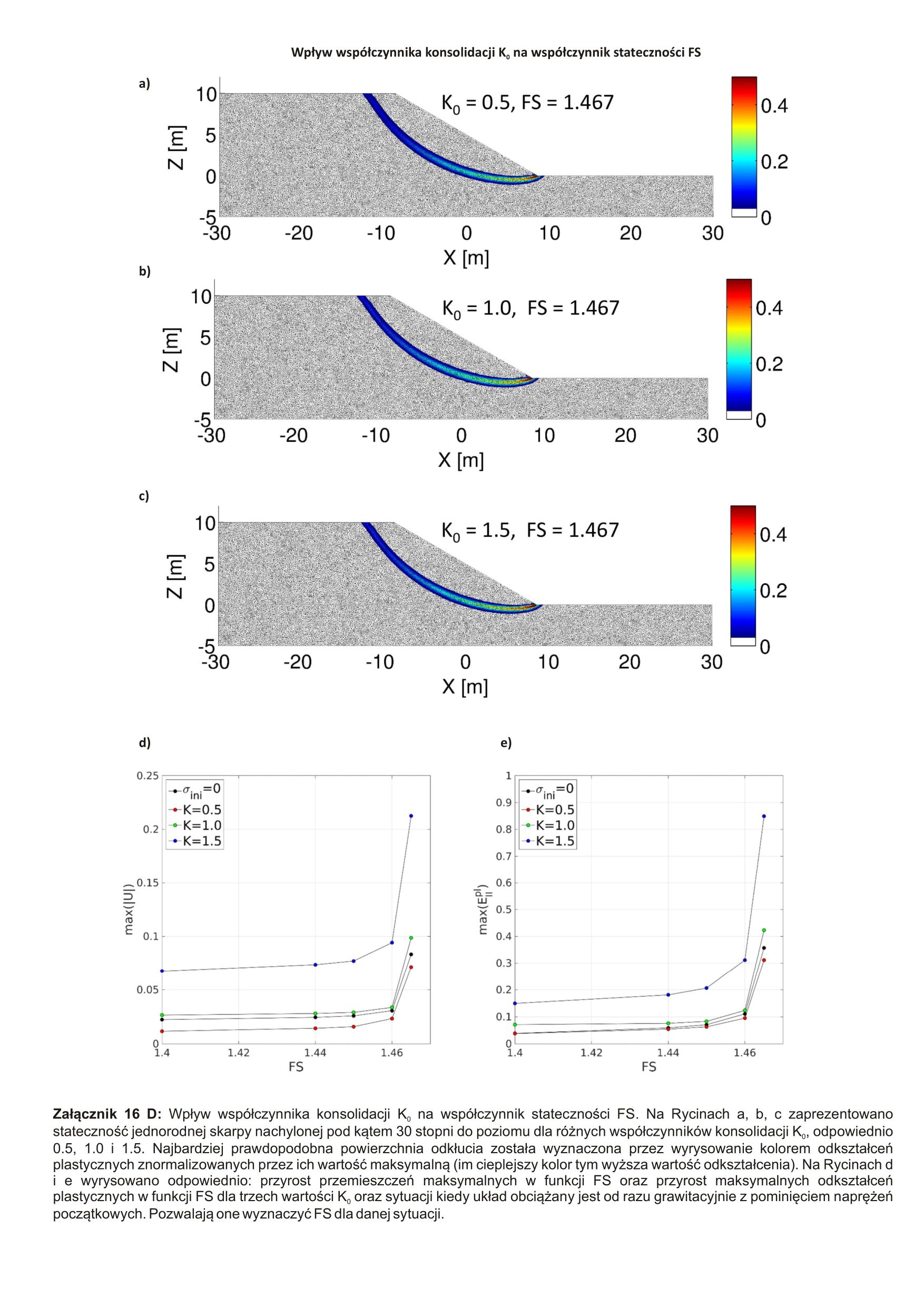
C4D - Impact of the consolidation factor on the stability factor
(
WWW:DOWNLOAD-1.0-http--download
)
C4D - Impact of the consolidation factor on the stability factor
C4D - Impact of the consolidation factor on the stability factor
K4D - Wpływ współczynnika konsolidacji na współczynnik stateczności
C4D - Impact of the consolidation factor on the stability factor
- OnLine resource
-
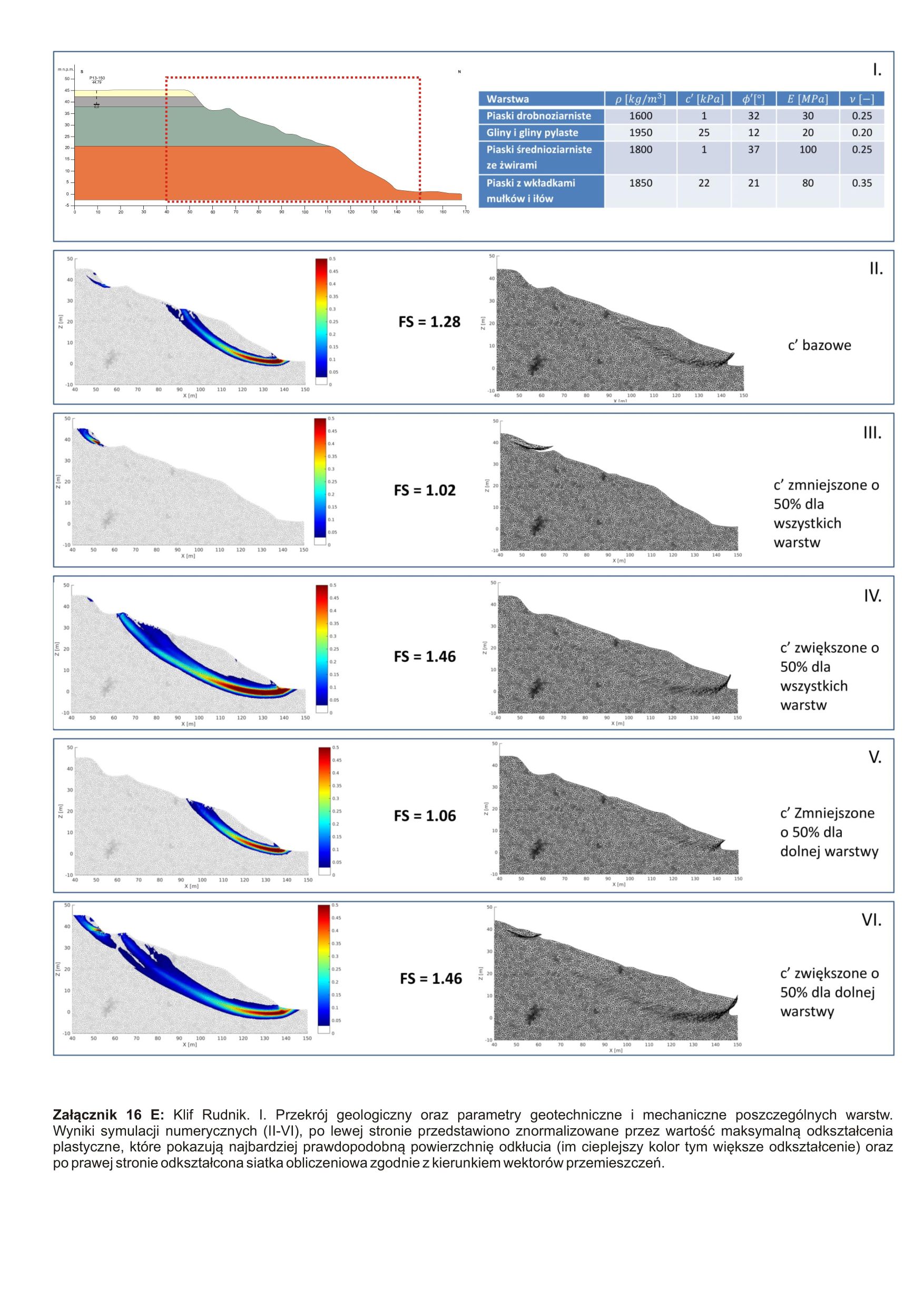
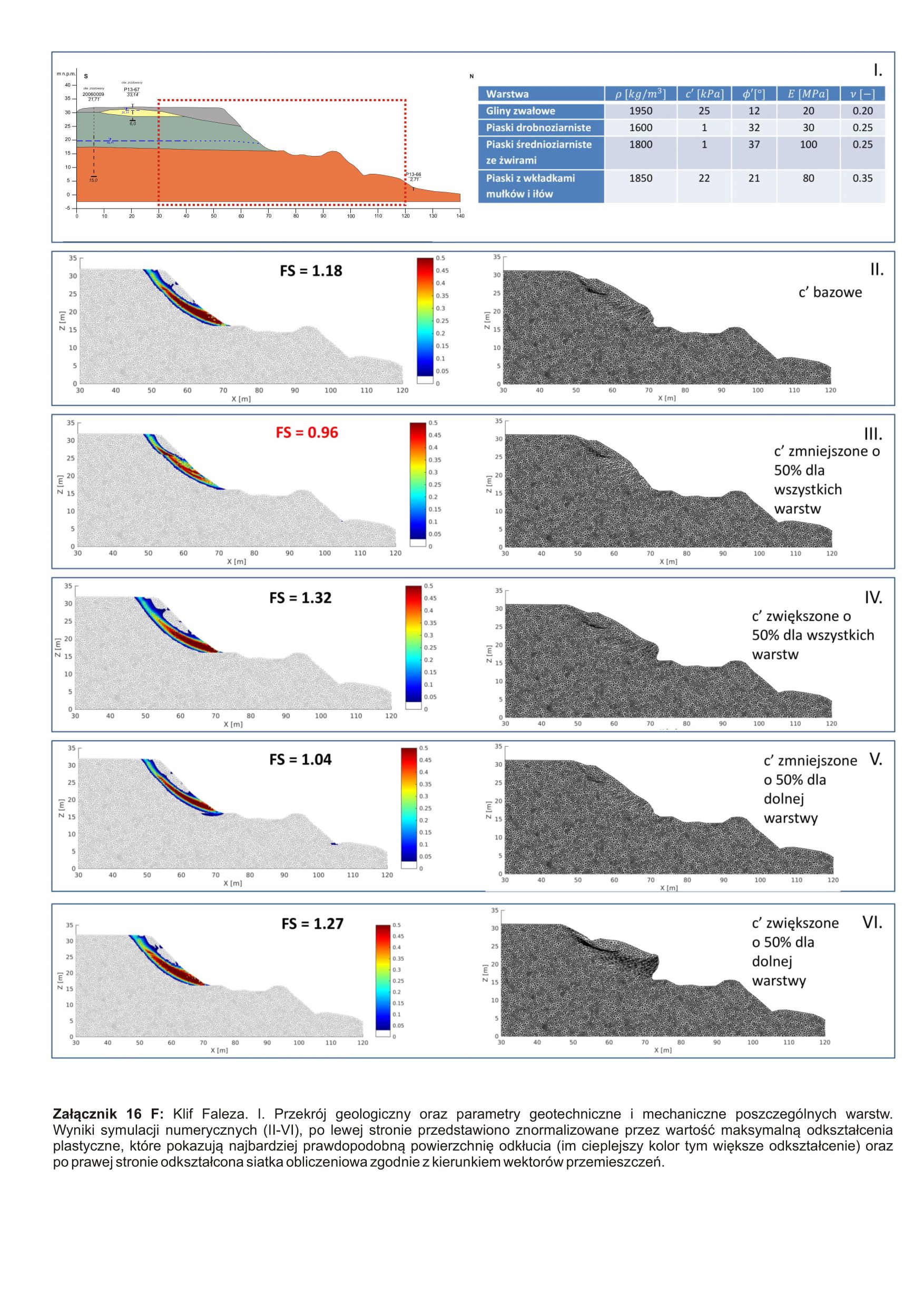
C4D - Rudnik Cliff
(
WWW:DOWNLOAD-1.0-http--download
)
C4D - Rudnik Cliff
C4D - Rudnik Cliff
K4D - Klif Rudnik
C4D - Rudnik Cliff
- OnLine resource
-
C4D - "Faleza" Cliff
(
WWW:DOWNLOAD-1.0-http--download
)
C4D - "Faleza" Cliff
C4D - "Faleza" Cliff
K4D - Klif Faleza
C4D - "Faleza" Cliff
- OnLine resource
-
C4D - Jastrzębia Góra Cliff
(
WWW:DOWNLOAD-1.0-http--download
)
C4D - Jastrzębia Góra Cliff
C4D - Jastrzębia Góra Cliff
K4D - Klif Jastrzębia Góra
C4D - Jastrzębia Góra Cliff
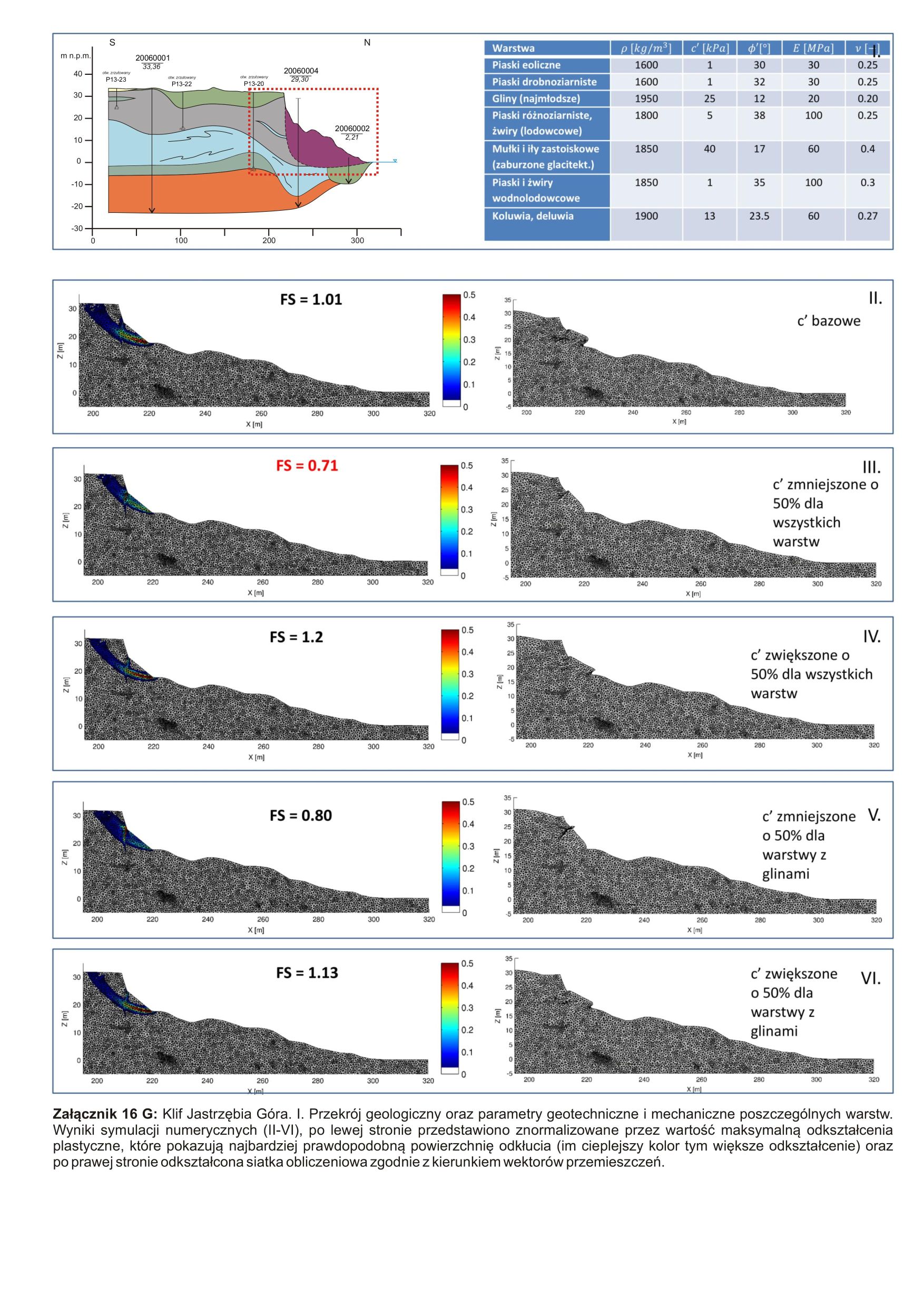
- OnLine resource
-
C4D - Impact of pore pressure on the stability of the Rudnik Cliff
(
WWW:DOWNLOAD-1.0-http--download
)
C4D - Impact of pore pressure on the stability of the Rudnik Cliff
C4D - Impact of pore pressure on the stability of the Rudnik Cliff
K4D - Wpływ ciśnienia porowego na stateczność klifu Rudnik
C4D - Impact of pore pressure on the stability of the Rudnik Cliff
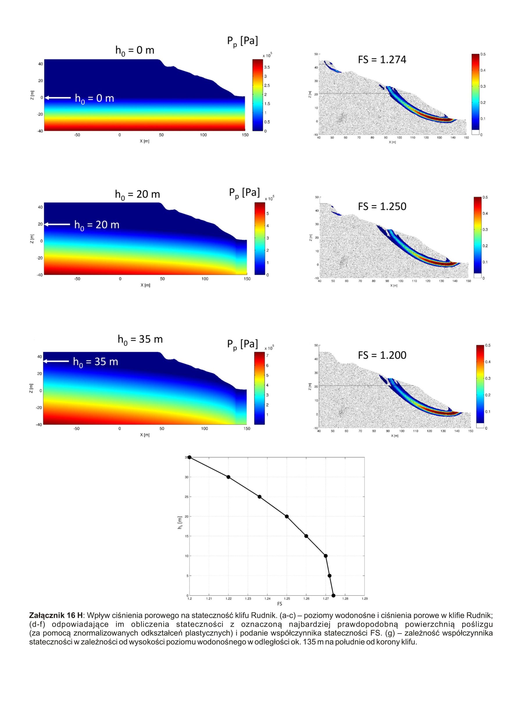
- OnLine resource
-
C4D - Impact of pore pressure on the stability of the Faleza Cliff
(
WWW:DOWNLOAD-1.0-http--download
)
C4D - Impact of pore pressure on the stability of the Faleza Cliff
C4D - Impact of pore pressure on the stability of the Faleza Cliff
K4D - Wpływ ciśnienia porowego na stateczność klifu Faleza
C4D - Impact of pore pressure on the stability of the Faleza Cliff
- OnLine resource
-
C4D - Structural model of selected sections of the spit coast
(
WWW:DOWNLOAD-1.0-http--download
)
C4D - Structural model of selected sections of the spit coast
C4D - Structural model of selected sections of the spit coast
K4D - Model strukturalny wybranych odcinków wybrzeża mierzejowego
C4D - Structural model of selected sections of the spit coast
- OnLine resource
-
C4D - Forecasting model of coastal changes - the spit section
(
WWW:DOWNLOAD-1.0-http--download
)
C4D - Forecasting model of coastal changes - the spit section
C4D - Forecasting model of coastal changes - the spit section
K4D - Model prognostyczny zmian wybrzeża – odcinek mierzejowy
C4D - Forecasting model of coastal changes - the spit section
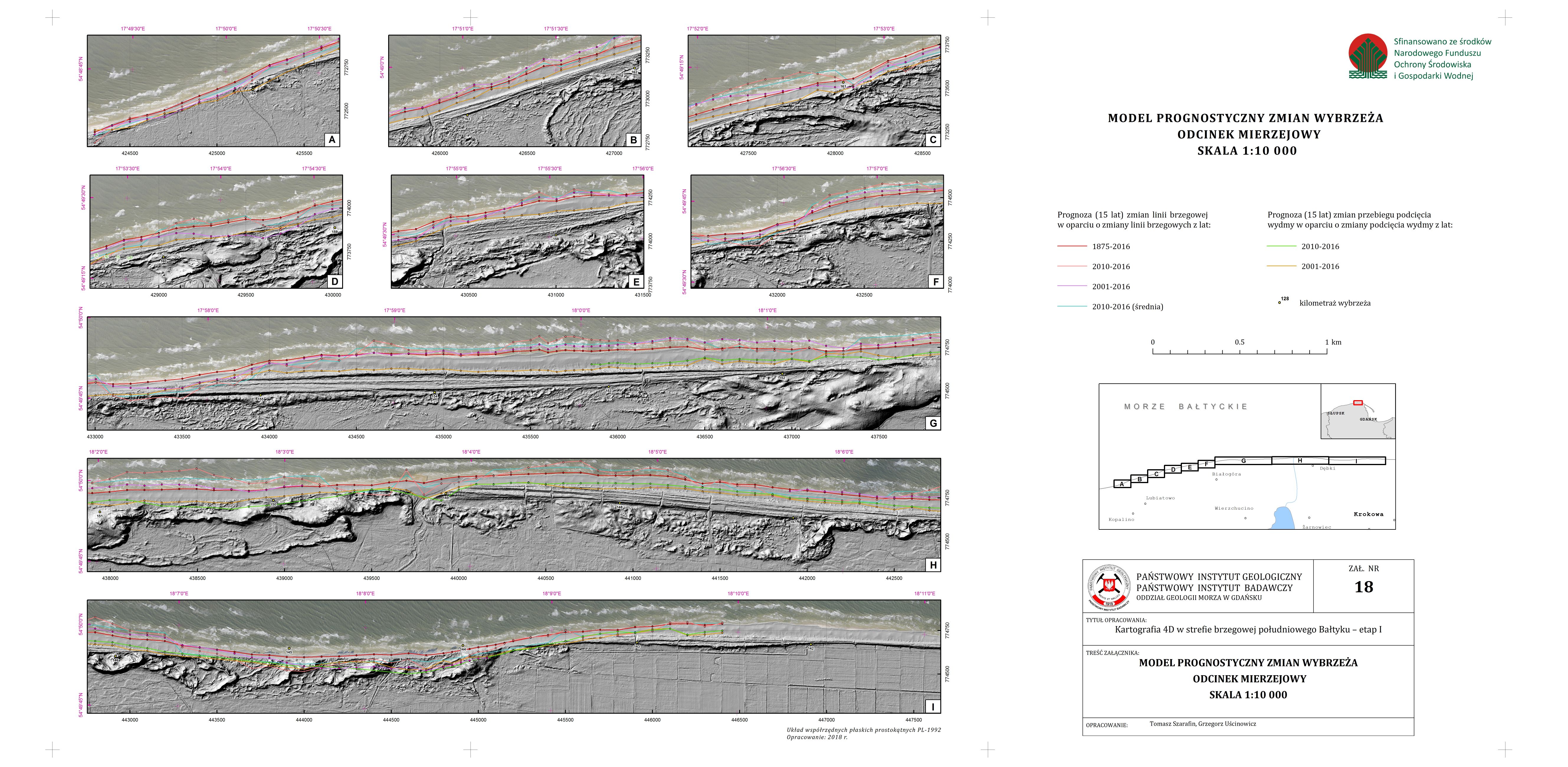
- OnLine resource
-
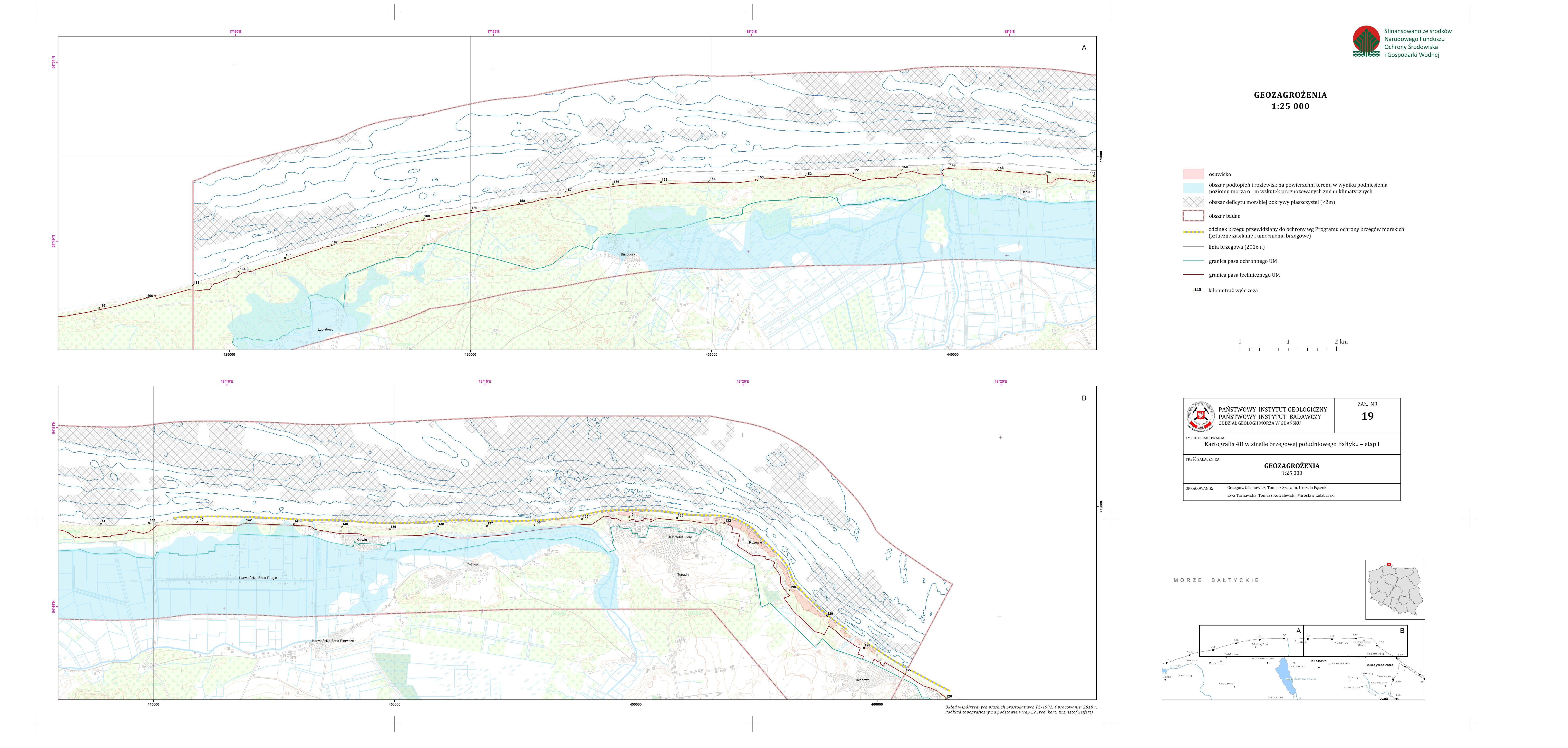
C4D - Geohazards
(
WWW:DOWNLOAD-1.0-http--download
)
C4D - Geohazards
C4D - Geohazards
K4D - Geozagrożenia
C4D - Geohazards
- Hierarchy level
- Dataset
Conformance result
- Date (Publication)
- 2010-12-08
- Explanation
-
See the referenced specification
See the referenced specification
- Pass
- Yes
Conformance result
- Date (Publication)
- 2008-12-04
- Explanation
-
See the referenced specification
See the referenced specification
- Pass
- Yes
- Statement
-
This data was obtained with an use of all known scientific standards.
This data was obtained with an use of all known scientific standards.
Dane te uzyskano z wykorzystaniem wszystkich znanych standardów naukowych.
This data was obtained with an use of all known scientific standards.
- File identifier
- urn:SDN:CDI:pgi.gov.pl:uuid:964c8d91-d436-4b64-a1c0-b6087384d8f5 XML
- Metadata language
- English
- Character set
- UTF8
- Hierarchy level
- Dataset
- Hierarchy level name
- CDI
- Date stamp
- 2022-07-25T12:58:53
- Metadata standard name
-
ISO 19115/SeaDataNet profile
- Metadata standard version
-
1.0
Overviews
Spatial extent
Provided by
