 PIG-PIB Katalog metadanych eCUDO.pl
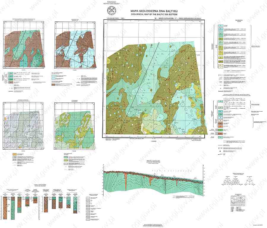
MGDB 1:200 000 - Arkusz (17) Próg Gotlandzko-Gdański
Geological map of the bottom of the Baltic Sea 1:200 000 - Sheet (17) Próg Gotlandzko-Gdański.
Geological map of the bottom of the Baltic Sea 1:200 000 - Sheet (17) Próg Gotlandzko-Gdański.
Mapa geologiczna Bałtyku 1:200 000 - Arkusz (17) Próg Gotlandzko-Gdański.
Geological map of the bottom of the Baltic Sea 1:200 000 - Sheet (17) Próg Gotlandzko-Gdański.
default
- Data (Publikacja)
- 2022-06-14
- Identyfikator
- urn:SDN:CDI:pgi.gov.pl:uuid:c7fbe1df-76e4-4f7f-8025-b5718b86776a
- Status
- Zakończony
- CI_PresentationFormCode
-
-
mapDigital
mapDigital
Mapa cyfrowa
Digital map
-
-
GEMET - INSPIRE themes, version 1.0
GEMET - INSPIRE themes, version 1.0
GEMET - INSPIRE themes, version 1.0
-
-
Geology
Geology
Geologia
Geology
-
- SeaDataNet Device Categories
-
- research vessel
- BODC Parameter Discovery Vocabulary
-
- Sediment grain size parameters
- BODC Parameter Discovery Vocabulary
-
- Mineralogical composition
-
Continents, countries, sea regions of the world.
Continents, countries, sea regions of the world.
Continents, countries, sea regions of the world.
-
-
Baltic Sea
Baltic Sea
Bałtyk
Baltic Sea
-
- Ograniczenie korzystania
-
no conditions apply
no conditions apply
Nie obowiązują żadne warunki
No conditions apply
- Inne ograniczenia
- Creative Commons Uznanie autorstwa 4.0 Międzynarodowa Licencja Publiczna
- Typ reprezentacji przestrzennej
- mapDigital
- Odległość
- 100 https://www.seadatanet.org/urnurl/SDN:P06::ULAA
- Język
- English
- Zbiór znaków
- Utf8
- Kategoria tematyczna
-
- Oceany
- Geoinformacja
))
- Data początkowa
- 1990-01-01
- Data końcowa
- 2002-12-31
- Unikalny identyfikator zasobu
- 4326
- Kod przestrzeni
-
SeaDataNet
- Format dystrybucji
-
-
INAPP
(
1
)
-
INAPP
(
1
)
- Zasób sieciowy
-
MGDB, Arkusz (17) Próg Gotlandzko-Gdański, JPG
(
WWW:DOWNLOAD-1.0-http--download
)
GMBB, Sheet (17) Próg Gotlandzko-Gdański, JPG
GMBB, Sheet (17) Próg Gotlandzko-Gdański, JPG
MGDB, Arkusz (17) Próg Gotlandzko-Gdański, JPG
GMBB, Sheet (17) Próg Gotlandzko-Gdański, JPG
- Zasób sieciowy
-
MGDB tekst, Arkusz (17) Próg Gotlandzko-Gdański, PDF
(
WWW:DOWNLOAD-1.0-http--download
)
GMBB text, Sheet (17) Próg Gotlandzko-Gdański, PDF
GMBB text, Sheet (17) Próg Gotlandzko-Gdański, PDF
MGDB tekst, Arkusz (17) Próg Gotlandzko-Gdański, PDF
GMBB text, Sheet (17) Próg Gotlandzko-Gdański, PDF
- Poziom
- Zbiór danych
Wynik zgodności
- Data (Publikacja)
- 2010-12-08
- Wyjaśnienie
-
See the referenced specification
See the referenced specification
- Aprobata
- Yes
Wynik zgodności
- Data (Publikacja)
- 2008-12-04
- Wyjaśnienie
-
See the referenced specification
See the referenced specification
- Aprobata
- Yes
- Oświadczenie
-
This data was obtained with an use of all known scientific standards.
This data was obtained with an use of all known scientific standards.
Dane te uzyskano z wykorzystaniem wszystkich znanych standardów naukowych.
This data was obtained with an use of all known scientific standards.
- Identyfikator pliku
- urn:SDN:CDI:pgi.gov.pl:uuid:c7fbe1df-76e4-4f7f-8025-b5718b86776a XML
- Język
- English
- Zbiór znaków
- Utf8
- Poziom hierarchii
- Zbiór danych
- Nazwa poziomu hierarchii
- CDI
- Oznaczenie daty metadanych
- 2022-07-25T12:58:53
- Nazwa standardu metadanych
-
ISO 19115/SeaDataNet profile
- Wersja standardu metadanych
-
1.0
