 PIG-PIB Katalog metadanych eCUDO.pl
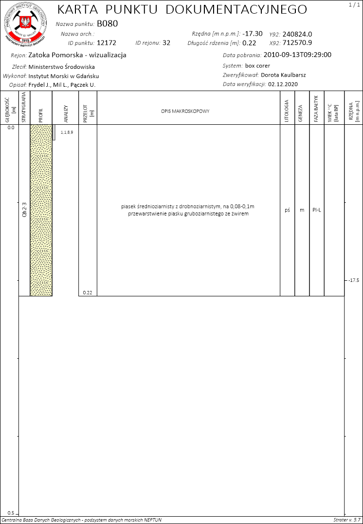
Borehole - 12172
Otwór wiertniczy - 12172
Borehole - 12172
Information from the borehole as a sampling point sheet, including: lithology, genesis, stratigraphy.
Informacje z otworu wiertniczego w formie karty punktu dokumentacyjnego, między innymi: litologia, geneza, stratygrafia.
Information from the borehole as a sampling point sheet, including: lithology, genesis, stratigraphy.
Simple
-
Data (Publikacja)Date (Publication)
- 2022-08-30
-
IdentyfikatorIdentifier
- urn:SDN:CDI:pgi.gov.pl:uuid:fbbac632-6397-4652-b714-a1f86b7be404
-
StatusStatus
-
ZakończonyCompleted
- Keywords
-
-
Borehole
Otwór wiertniczy
Borehole
-
-
GEMET - INSPIRE themes, version 1.0
GEMET - INSPIRE themes, version 1.0
-
-
Geology
Geologia
Geology
-
-
SeaDataNet Device Categories
-
- research vessel
-
BODC Parameter Discovery VocabularySłownik parametrów badawczych BODCBODC Parameter Discovery Vocabulary
-
- Lithology of rocks
-
Continents, countries, sea regions of the world.
Continents, countries, sea regions of the world.
-
-
Baltic Sea
Bałtyk
Baltic Sea
-
-
Use limitationOgraniczenie korzystaniaUse limitation
-
no conditions apply
nie obowiązują żadne warunki
no conditions apply
-
Other constraintsInne ograniczeniaOther constraints
-
Creative Commons Attribution 4.0 International LicenseCreative Commons Uznanie autorstwa 4.0 Międzynarodowa Licencja PublicznaCreative Commons Attribution 4.0 International License
-
Typ reprezentacji przestrzennejSpatial representation type
-
WektorVector
-
Typ reprezentacji przestrzennejSpatial representation type
-
mapDigitalmapDigital
-
OdległośćDistance
- 1 https://www.seadatanet.org/urnurl/SDN:P06::ULAA
-
JęzykMetadata language
- English
-
Zbiór znakówCharacter set
-
Utf8UTF8
-
Kategoria tematycznaTopic category
-
-
OceanyOceans
-
GeoinformacjaGeoscientific information
-
PołożenieLocation
-
))
- Begin date
- 2010-09-13T09:29:00
- End date
- 2010-09-13T09:29:00
-
Unikalny identyfikator zasobuUnique resource identifier
-
43264326
- Codespace
-
SeaDataNet
-
Format dystrybucjiDistribution format
-
-
A popular geospatial vector data format for geographic information system software developed and regulated by ESRI
(
1
)
-
A popular geospatial vector data format for geographic information system software developed and regulated by ESRI
(
1
)
-
Zasób sieciowyOnLine resource
-
Borehole, shapefile (SHP)Otwór wiertniczy, plik SHPBorehole, shapefile (SHP)
(
WWW:DOWNLOAD-1.0-http--download
)
Borehole, shapefile (SHP)
Otwór wiertniczy, plik SHP
Borehole, shapefile (SHP)
-
Zasób sieciowyOnLine resource
-
Borehole, sampling point sheet (PDF file)Otwór wiertniczy, karty punktu dokumentacyjnego (plik PDF)Borehole, sampling point sheet (PDF file)
(
WWW:DOWNLOAD-1.0-http--download
)
Borehole, sampling point sheet (PDF file)
Otwór wiertniczy, karty punktu dokumentacyjnego (plik PDF)
Borehole, sampling point sheet (PDF file)
-
Zasób sieciowyOnLine resource
-
Borehole, explanation of symbols (PDF file)Otwór wiertniczy, objaśnienia symboli (plik PDF)Borehole, explanation of symbols (PDF file)
(
WWW:DOWNLOAD-1.0-http--download
)
Borehole, explanation of symbols (PDF file)
Otwór wiertniczy, objaśnienia symboli (plik PDF)
Borehole, explanation of symbols (PDF file)
-
PoziomHierarchy level
-
Zbiór danychDataset
Wynik zgodności
Conformance result
-
Data (Publikacja)Date (Publication)
- 2010-12-08
-
Explanation
-
See the referenced specification
-
AprobataPass
- Yes
Wynik zgodności
Conformance result
-
Data (Publikacja)Date (Publication)
- 2008-12-04
-
Explanation
-
See the referenced specification
-
AprobataPass
- Yes
-
StatementOświadczenieStatement
-
This data was obtained with an use of all known scientific standards.
Dane te uzyskano z wykorzystaniem wszystkich znanych standardów naukowych.
This data was obtained with an use of all known scientific standards.
-
Identyfikator plikuFile identifier
- urn:SDN:CDI:pgi.gov.pl:uuid:fbbac632-6397-4652-b714-a1f86b7be404 XML
-
JęzykMetadata language
- English
-
Zbiór znakówCharacter set
-
Utf8UTF8
-
Poziom hierarchiiHierarchy level
-
Zbiór danychDataset
-
Nazwa poziomu hierarchiiHierarchy level name
-
CDICDI
-
Oznaczenie daty metadanychDate stamp
- 2022-07-25T12:58:53
- Metadata standard name
-
ISO 19115/SeaDataNet profile
- Metadata standard version
-
1.0
Overviews
Spatial extent
Provided by
